In January 1821, representatives of the Creek Nation signed the first Treaty of Indian Springs, ceding to the federal government millions of acres between the Ocmulgee and Chattahoochee Rivers. Encompassing the future sites of the City of Atlanta and its suburbs to the south and east, the ceded territory was quickly organized into five large counties, out of which dozens of smaller counties have been created. Surveyors, working under contract with the State, platted the land into districts that were to be “nine miles square, as near as practicable,” and into land lots of 202½ acres, or a little over half mile square. The districts and land lots remain the foundation of any description of real estate today, while the arbitrary lines on plats have left their mark in the landscape: North Avenue, West Peachtree Street, Eighth Street, and Northside Drive are but a few of Atlanta’s thoroughfares that run along land-lot lines.
For the Seventeenth District, which encompasses what are now the City of Atlanta north of a line along Eighth Street as well as most of Sandy Springs, the State survey in 1821 left an extraordinary level of detail beyond land-lot boundaries, creeks, and boundary trees. Peachtree and River Roads, which were then but a few years old, and the Hightower and Sand Town Trails, which had been in use for centuries were delineated, but also dozens of secondary trails, or paths as they were sometimes called. Some may not have been of ancient origin, but many were the sort of interconnecting routes of travel common wherever there is human settlement. That level of detail is not found in the surveys of the surrounding districts, including the Fourteenth District, encompassing most of the city south of Eighth Street, and the Thirteenth and Eighteenth Districts, encompassing western DeKalb County.
Few if any of these trails have been corroborated by archaeological evidence, but historical documentation, especially the state land surveys, describes an elaborate network of trails. A comparison of that with the streets and highways that developed in the second quarter of the nineteenth century suggests that an important part of Atlanta’s present pattern of streets and highways—including much of Peachtree Road and some, but not all, of Peachtree Street—evolved out of ancient trails.
Direct correlation of a trail with a modern roadway is sometimes hampered by the limitations of a chain-measured survey of wooded, hilly terrain, where it might be difficult to obtain the level lines that were critical to accurate results. This sometimes lead to errors that might later require a corrected plat. Direct correlation of trails to modern thoroughfares might also be made more difficult because of the inability of the surveyor, who was only running boundary lines, to see the entire length of a trail’s route through a land lot, and irregularities in a trail’s route may sometimes have been inadvertently eliminated in drafting the final plat.
The routes of foot paths and trails were not immutable either; fallen trees or flooding from a beaver dam, for example, might precipitate permanent rerouting of a trail. Finally, the narrow, sometimes meandering routes of the simple footpaths have been overwritten, as it were, by wagon roads and city streets many times wider so there is but the ghost of the ancient foot path remaining today. Nevertheless the network of trails mapped by Terrrell in 1821 is an early imprint on Atlanta’s palimpsest and a reminder that humans have been walking this land for thousands of years.
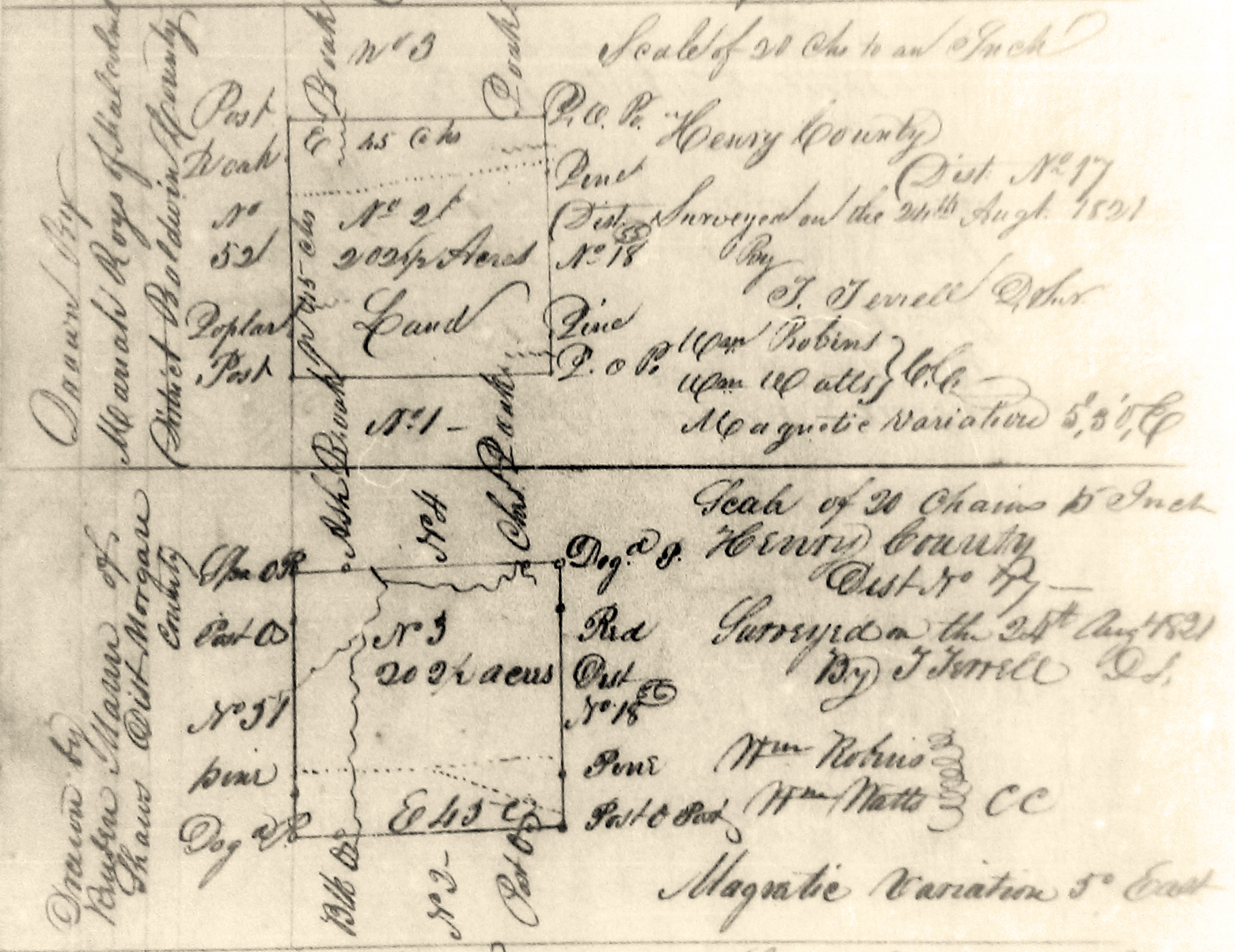
Figure 1. Copy from microfilm of Thompson's 1821 plat of Land Lots 2 and 3, Seventeenth District, encompassing part of what is now Morningside and Lenox Park. (Records of the Surveyor General, Georgia Archives) |
People everywhere have always walked, "veining the earth with paths visible and invisible, symmetrical or meandering," as author Thomas Clark put it. Long before European contact, the indigenous people had created an elaborate system of foot paths crisscrossing eastern North America, some following tracks worn by buffalo and other megafauna through eons of use prior to the arrival of humans over 13,000 years ago. These ancient trails were often used for travel over quite long distances, whether in trade or in war or simply in maintaining contact with distant family members. [1]
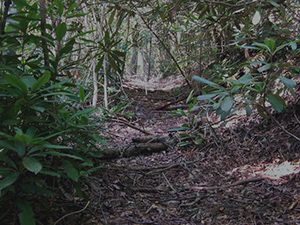 Figure 2. Some of the most important foot paths were much like this portion of the Unicoi Trail preserved near Conasauga Creek in the Cherokee National Forest. (Photo by Dirt e Deeds, 2011, CC BY-SA 3.0. Wikipedia Creative Commons) |
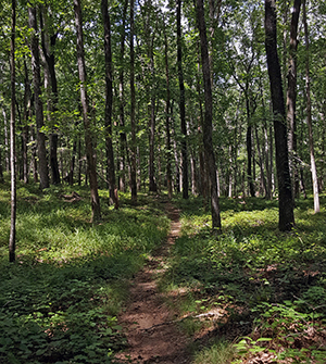 Figure 3. Well-traveled trails might have resembled this modern foot path near Arabia Mountain in southern DeKalb County (Photo by Tommy H Jones, 2017) |
The early trails avoided rough or swampy terrain and dense undergrowth such as laurel thickets and cane brakes for the same reasons we do, ease of travel and protection of footwear and garments. These trails often followed ridgelines and other high ground, which typically offered firmer footing and fewer obstacles to travel, and they were usually less than two feet wide as people wound their way single-file through the area's hilly and heavily wooded landscape. With the introduction of horses among the southeastern Indians in the 1690s, some trails were widened to four, five, or even six feet in width.
The routes of trails were often dictated by the presence of convenient crossings of the area's numerous rivers and streams. One of the most notable of those crossings near modern-day Atlanta was Shallow Ford on the Chattahoochee River, eighteen miles north of downtown but now drowned by Bull Sluice Lake. There were other river fords downstream, including near the mouth of Peachtree Creek and, ten miles downstream from there, at Buzzards Roost. Rock Bridge on the DeKalb-Rockdale County line was a natural bridge of sorts over the Yellow River and an important landmark for early people as well. Other natural features were also destinations, including Soapstone Ridge, six miles southeast of downtown, where steatite was being quarried, worked, and widely traded as early as 1500 BCE, and Stone Mountain, where the trail up its western slope has been in use for thousands of years.
The fall line on the Savannah River, a few miles upstream from present-day Augusta, is the site of some of the earliest, more or less permanent, human occupation yet documented in the southern Piedmont, beginning as early as four thousand years ago. A series of important, long-distance trails radiated from those falls, to the west forking and forking again into paths that, during the historic period, led to the Cherokee towns in northern Georgia and Tennessee and to the Creek towns on the lower Chattahoochee, Tallapoosa, and Coosa Rivers.
Most trails of these trails were not so much a single entity as they were a braid of alternative routes, some of which might, for example, provide a shorter route but be impassable in wet weather, others longer but more reliable. In addition trails often went by different names, depending on one's destination, similar to the nomenclature used for area roads. The same thoroughfare is called, for example, Decatur Street east of Five Points and Marietta Street to the west. As the noted ethnographer John R. Swanton (1873–1958) cautioned, "there is, and always must be, considerable artificiality in the determination of what constitutes a trail, and where a trail begins and ends." He also noted that it is "largely a matter of convention which of two branches of a trail should be considered as the fork and which as the main trail." [2]
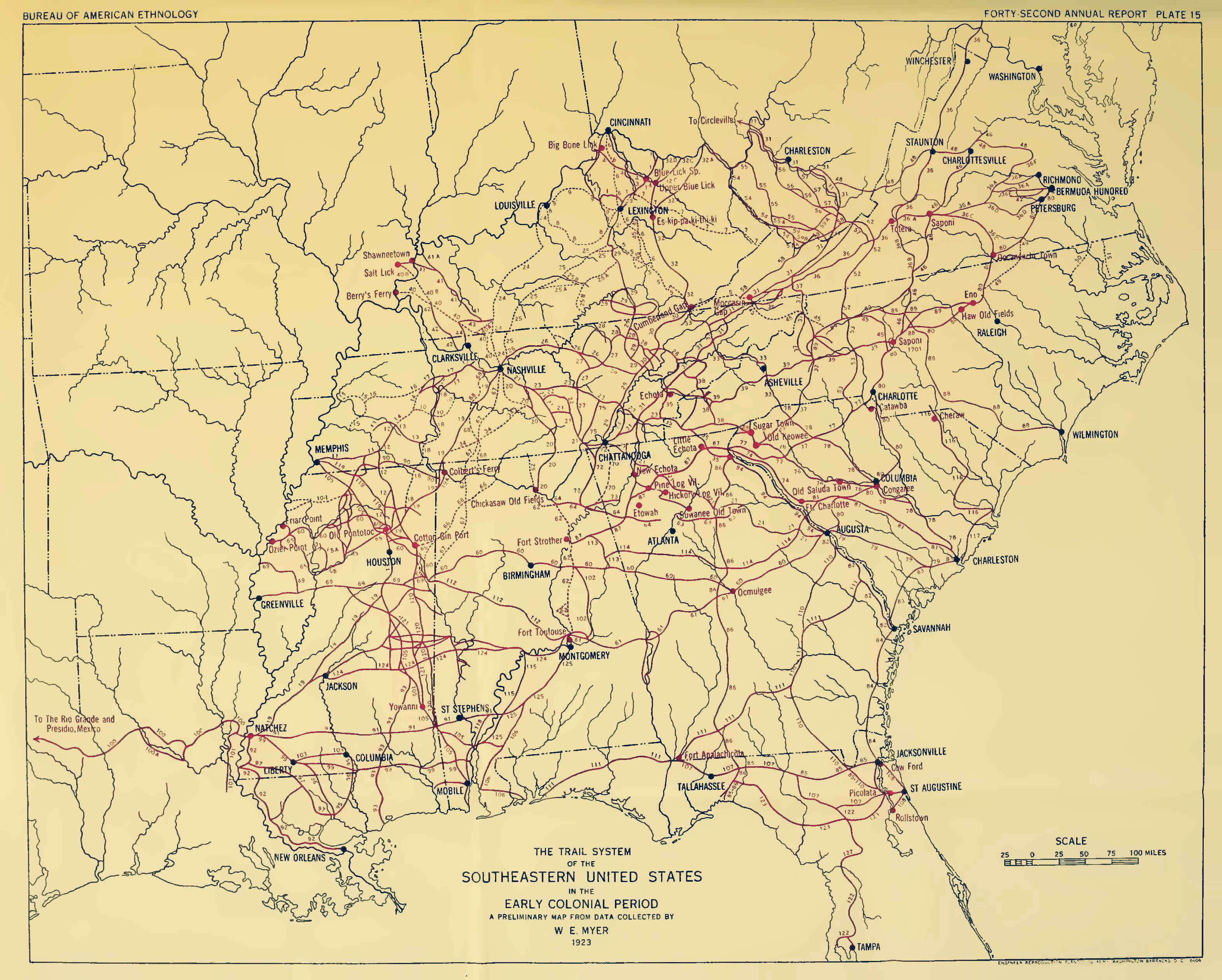
Figure 4. W. E. Myers's map of major Indian trails across the southeastern United States. ("Indian Trails of the Southeast," Forty-second Annual Report of the Bureau of American Ethnology: 747) |
![]()
Atlanta's Ancient Trails
The Hightower Trail was one of the best known of the ancient, long-distance trails near what is now the City of Atlanta. It diverged from the Upper Creek Trading Path just west of the Oconee River in eastern Morgan County and led in a northwesterly direction via Rock Bridge to Shallow Ford. From there it continued to the great convergence of trails in and around Etowah near Cartersville, the site of a magnificent Mississippian mound complex. The exact route of most ancient trails is often difficult to determine, but the Hightower Trail was used in the Treaty with the Creeks in 1818 to define part of Georgia's new western border. In 1821 when another treaty shifted the border even further to the west, the trail became the line between Gwinnett and DeKalb counties and part of it remains so today. That original boundary, and so the location of Shallow Ford, can still be readily identified where the line between the Sixth and Seventeenth Districts in north Fulton County meets the river. A segment of the route also survives west of Dunwoody Place and is still called Hightower Trail. [3]
Just west of Rock Bridge, another long-distance trail diverged from the Hightower Trail and led in a westerly direction. Often called the Sand Town Trail, it crossed the Chattahoochee River at Buzzards Roost, an island just downstream from the mouth of Utoy Creek, about nine miles west of downtown. From there, it continued on to the towns of the Upper Creek in Alabama. The main route of the Sand Town Trail appears to have followed what is now Rockbridge Road to Decatur and then MARTA's East Line to Five Points in downtown Atlanta and southwest along the high ground between Utoy and Camp Creeks to Buzzards Roost, where the river could be forded. Part of the route of the Sand Town Trail is approximated in the block of modern Trinity Avenue west of Forsyth Street and Peters Street in downtown Atlanta and Cascade Road in southwest Atlanta. [4]
In what is now downtown Decatur, the Sand Town Trail crossed an important north-south trail connecting Flat Shoals and Indian Springs to Shallow Ford, its route still traced in parts of Candler, Clairmont, and Shallowford Roads. A trail to Standing Peachtree left the Shallowford Trail a mile or so north of the Sand Town Trail, trending in a westerly direction along a route approximated by today's N. Decatur Road as it runs through Druid Hills, Rock Springs Road through Morningside, and part of Montgomery Ferry Road across Piedmont Heights into Sherwood Forest. The route westward from there is lost until picked up again with Collier Road through Collier Hills and on to DeFoors Ferry Road and the site of Standing Peachtree.
Just east of what is now Briarcliff Road, a trail diverged to the south. Designated "Sand Town Path" on the State surveys, it is shown looping through Morningside and crossing the southeast side of Piedmont Park. Delineation of the trail ended near what is now the intersection of Eighth Street and Argonne Avenue, which is at the southern boundary of the Seventeenth District. The trail certainly continued in a southerly direction from there, but it was not delineated in the surveys for the adjoining Fourteenth District. Considering the topography and the route of other trails recorded in the 1821 surveys (of which more below), it may be that the southern end of this segment of the "Sand Town Path" was also the genesis of what is now Peachtree Street in Downtown Atlanta. [5]
Finally there was what has been called the Peachtree Trail, which may have been part of a series of trails that followed the high ground that parallels the the Chattahoochee River from Tugaloo in present-day Stephens County and the other Lower Cherokee towns in northeastern Georgia and western South Carolina. Passing Suwanee, site of a Shawnee town that had been abandoned before 1780, the Peachtree Trail continued southwesterly before branching just west of Duluth, with one branch following the high ground on the north side of Nancy Creek, the other following the ridge on the south, and Standing Peachtree being the destination of both.
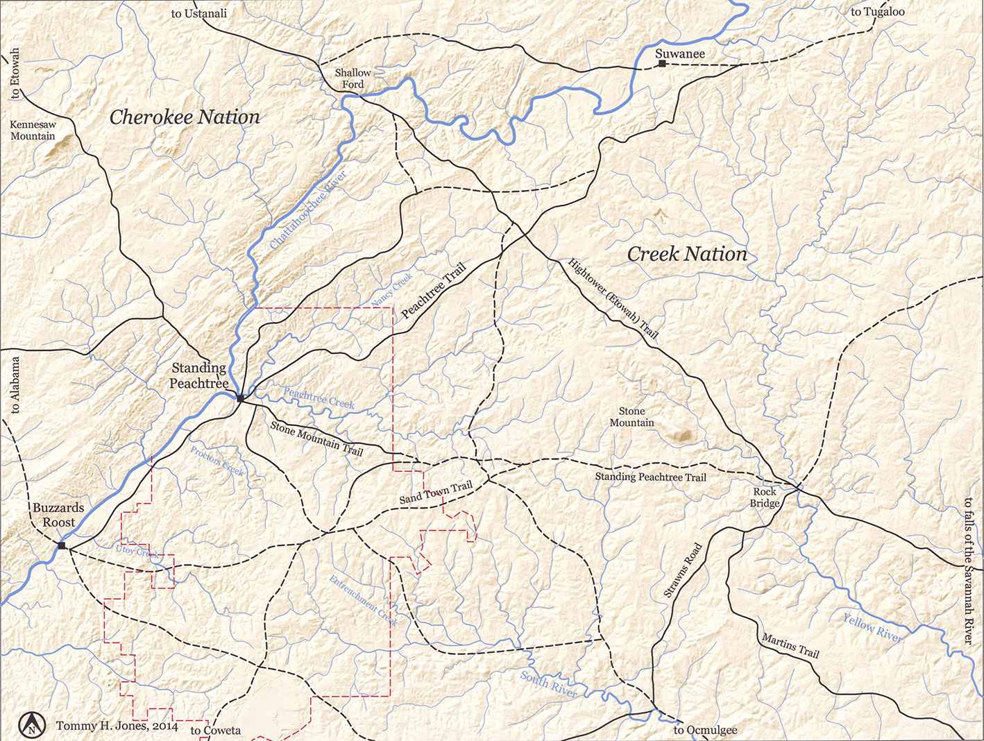
Figure 5. USGS map annotated to delineate general routes of Indian paths and trails that existed in the eighteenth and early nineteenth centuries. Red lines indicate the corporate limits of the City of Atlanta. Solid lines indicate the routes of trails delineated on the district plats of survey and/or the plats of individual land lots in 1821. Black dashed lines indicate the approximate route of other important trails that are documented elsewhere in the historical record. (Annotations by Tommy H Jones, 2014) |
![]()
Standing Peachtree
The most important of the few Indian settlements around what is now metropolitan Atlanta was Standing Peachtree, located on the Chattahoochee River near the mouth of Peachtree Creek, six miles northwest of downtown, where the river could be forded at least part of the year. The archaeological record suggests that the site was first inhabited during the Mississippian period, perhaps a thousand years ago. Clusters of houses amid fields of corn, beans, and squash were scattered on both sides of the river for several miles, but Standing Peachtree was the primary village. The State's land surveys in 1821 show a convergence of trails around Land Lot 231, which encompasses the mouth of Peachtree Creek and the heart of Standing Peachtree. Just west of what is now Ridgewood Road, near the center of the land lot and encircled today by Coronet Way, was a large earthen mound, and there was at least one more mound across the river. Still others could be found further down the river.
The Creek called the place Pakanahuili, with huili the Muscogee word for "standing," an adjective often found in early place names such as Standing Boy Creek near Columbus and Standing Rock near Senoia. As for the tree, some have argued that it was not a peach tree at all, but a “pitch tree,” a great pine which grew on the hill on the north side of the creek and which the Indians blazed for its resin, or pitch. [6]
The most widely accepted explanation for the name is contained in an 1897 newspaper interview with noted Atlanta pioneer George Washington Collier (1814–1903). He had come to the area with his family just after the War of 1812 and delivered mail from the post office at Standing Peachtree to Allatoona in what is now southeastern Bartow County in the early 1830s. He recalled that "[t]here was a great huge mound of earth heaped up there—big as this house, maybe bigger—and right on top of it grew a big peach tree." That, Collier said, was the origin of the name. [7]
Peaches were introduced into the New World by the Spaniards in the late sixteenth century and were often cultivated by the Indians; the great naturalist William Bartram noted "old Peach and Plumb orchards" in his travels through the upper Savannah River valley in the 1770s. Mounds at Standing Peachtree and elsewhere in the vicinity of Atlanta have been obliterated, some within the last fifty years, but their presence around the mouth of Peachtree Creek is documented in the historical record. The most prominent of the mounds was destroyed when the city built the pumping station for its waterworks in 1893, but it nevertheless may be true that a solitary peach tree, growing on top of an ancient Mississippian mound, gave rise to the place's name, "Standing Peach Tree." [8]
The place first appears in the historical record as "the standing Peach Tree” in a letter dated 27 May 1782 from John Martin, head of the Georgia militia, to Gen. Andrew Pickens, who led the South Carolina militia. Having just returned from a meeting with friendly Muscogee chiefs, Martin pleaded for assistance against the faction of the Creek Nation that was allied with the British in the ongoing American war for independence. He warned the general that "Mr. McIntosh with a strong party of Cowetas etc. were to rendezvous at the Standing Peach Tree the 26th of this month and they were afterwards to meet at the Big Shoal where to fall on the Okonnys on our Frontiers, therefore we have every reason to expect they will be in upon our back settlements in about 8 or 10 days at the farthest." The outcome of that particular threat is unclear, but Georgia's conflict with the Creek would continue for over forty years. [9]
In August 1790, representatives of the Creek Nation signed a treaty with United States commissioners that, in addition to guaranteeing "perpetual peace and friendship," fixed Georgia's western frontier at the Oconee River, sixty or seventy miles east of today's Atlanta. It did not remain there long. A treaty in 1805 pushed the boundary thirty or forty miles further west to the Ocmulgee and Alcovy Rivers and also provided that "the government of the United States shall forever hereafter have a right to a horse path, through the Creek country, from the Ocmulgee to the Mobile." Ostensibly a post road, the Creek were irate to discover that simple foot logs over the creeks, as stipulated in the treaty, had morphed into bridges and the horse path itself into a wagon road, all part and parcel of Gen. Andrew Jackson's strategy to destroy the Creek confederacy. With these roads, one historian noted, "the palimpsest was scored again as the trading paths, post roads, and traveler's routes were rutted with commissary wagons and heavy weaponry."[10]
In June 1812 war broke out between the United States and Great Britain, and at the same time the Cree Nation was descending into civil war. The so-called Red Stick faction of the Creek was more than ready to fight on the side of the British, and their raids on the Georgia and Alabama frontier culminated in a dreadful massacre of white settlers, militia, and their Indian allies at Fort Mims in Alabama on 30 August 1813. By October, the federal agent for the Creek reported to the commander of the Georgia Militia that the Red Sticks were threatening to destroy all of the Lower Creek towns and to "then take the post road, enter Georgia, ravage all before us out round Hog Mountain," which was then the westernmost point on the Georgia frontier. The state militia's fort at Hog Mountain was soon rebuilt and its garrison strengthened as state, federal, and Indian forces combined to put down the Red Sticks.
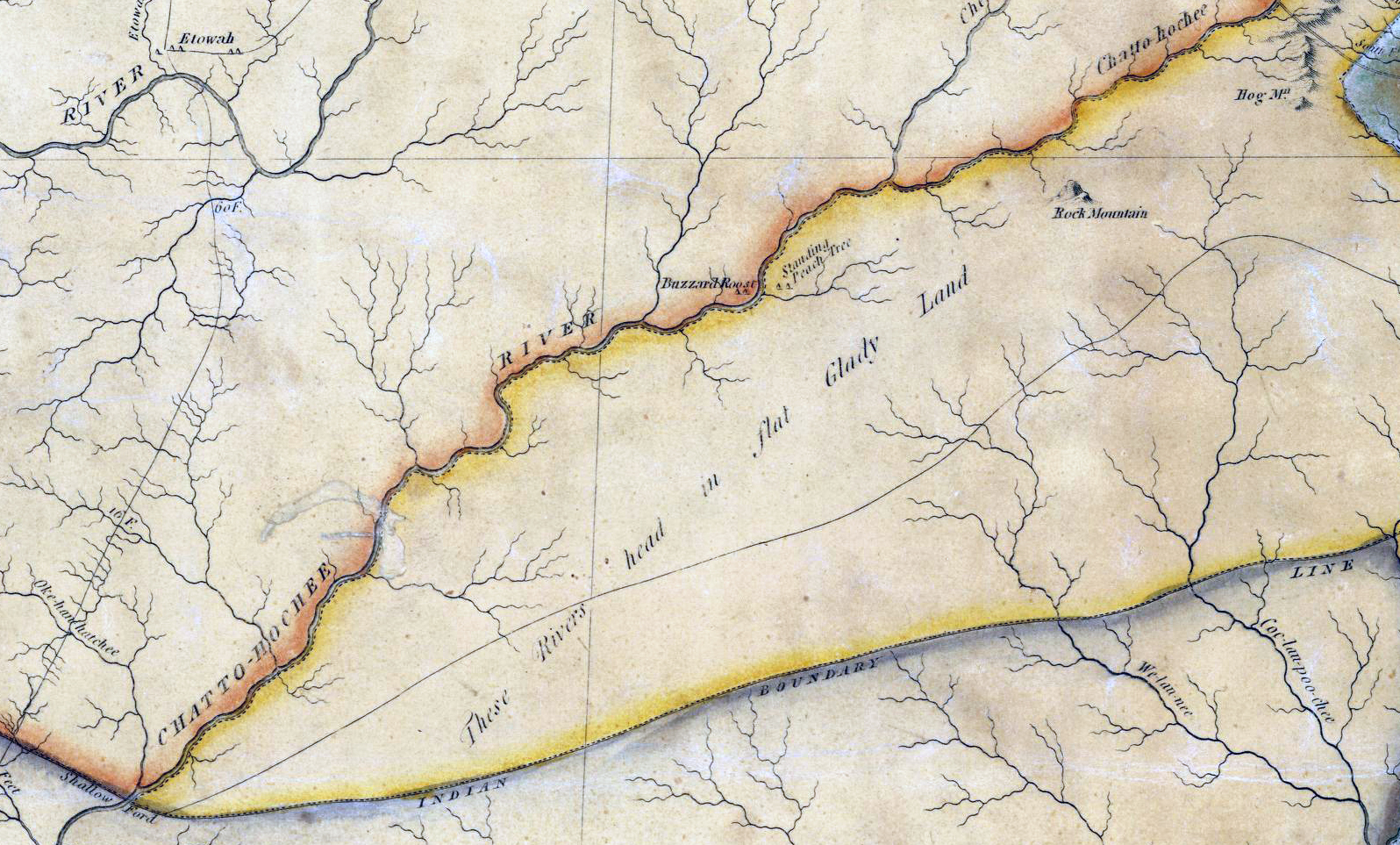
Figure 6. Detail from Eleazar Early's map of Georgia, published in 1818 and the first to depict the most-recent Creek land cession. It is also the earliest state map to show Standing Peachtree, but the map is very distorted, with Shallow Ford (lower left) far south of its actual location and Buzzard Roost and Standing Peachtree (just above center) on opposite banks of the Chattahoochee River upstream from Shallow Ford when they were themselves miles apart and downstream from the ford. ( Historic Maps, Surveyor General, RG 3-8-65, Georgia Archives) |
![]()
Peachtree Road
The logistics of supplying the main military garrison at Fort Mitchell overland proved daunting, and a plan was devised to build a palisaded, log fort on the Chattahoochee River at Standing Peachtree. Below that point, the river was navigable by shallow-draft flatboat, which the military intended to use to supply its garrison at Fort Mitchell, a hundred miles to the southwest. In early January 1814, Maj. Thomas Bourke of the Army Quartermaster Corps blazed a road between the two forts, reporting to his superior in a letter dated 11 January 1814 that he found eighteen miles of the proposed forty-mile route "had been made use of by Waggons already." [11]
The Army hired local contractors—Robert Young (1760-1851), Isham Williams (1776–1852), and William Nesbit (1789-1863)—who in turn engaged crews of men to actually clear the remainder of the road. It is thought that the new road incorporated ancient trails, but precisely where the route might have deviated from the earlier trails remains uncertain. In some places the surveyors are likely to have identified a new route better suited for a wagon road as they worked their way to the southwest along the high ground between Peachtree and Nancy Creeks to Standing Peachtree. By the spring of 1814, the road was more or less complete.
Designated on early maps "the road to Standing Peach Tree," it soon became "the Peach Tree Road," contracting to "Peachtree Road" by the 1860s. Construction of the Air Line Railroad in the 1870s and the interstate highways a hundred years later have altered the road's route in places but much of it can still be traced in a series of modern thoroughfares running through landscapes rural, suburban, and intensely urban.
The War Department also extended a "river road" from Standing Peachtree south to Sand Town. Like the Peachtree Road and other similar military roads in Georgia and Alabama, it facilitated the United States' slow-motion invasion of the Creek Nation. Before 1821, the Peachtree and River Roads appear to have been the only wagon roads in what became the City of Atlanta, but there were soon others.
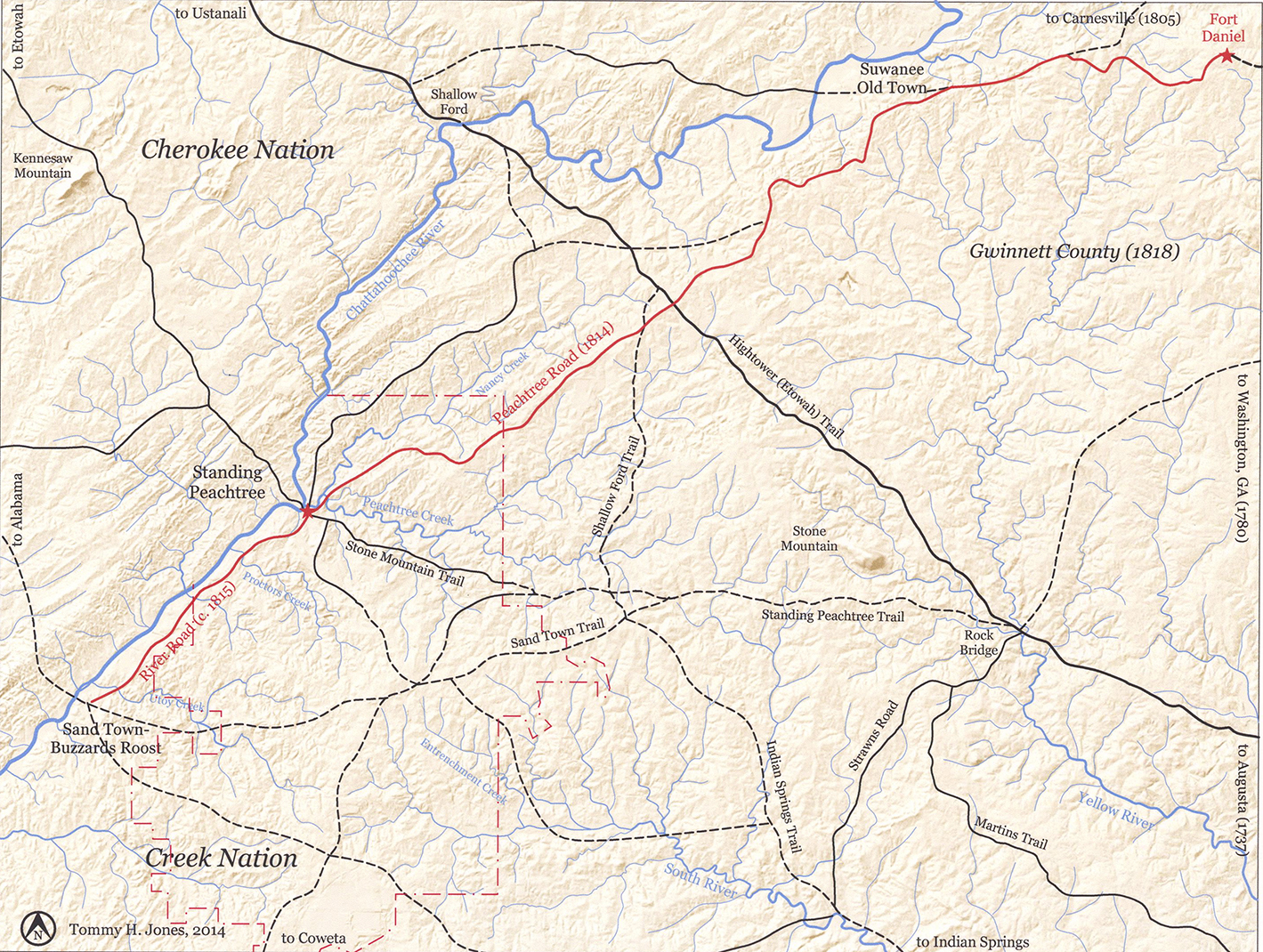
Figure 7. USGS map annotated to highlight the routes of Peachtree and River Roads as they were delineated on the district plats of survey in 1821. The solid lines denote significant trails that are shown on the plats of survey and/or individual land-lot surveys; the dashed lines are trails documented in the historical record but not in those surveys. (Annotations by Tommy H Jones, 2014.) |
![]()
1821 Survey
In vain the Creek Nation tried to define and protect its borders in the early nineteenth century, but regardless of any treaty guarantees, the invasion of their nation by a flood of white settlers continued. With little opposition from the State of Georgia, the newcomers flouted federal and tribal law by hunting, fishing, growing crops, and establishing large plantations inside the boundaries of the Creek Nation. Federal troops were sent to destroy farms, burn houses and remove the “intruders,” but as soon as the soldiers were gone, the squatters were back. Col. Hugh Montgomery, the federal government’s Indian agent, was “at a loss what to do” and bemoaned in a letter to the governor "the prevailing idea in Georgia (especially among the lower class) . . . [is] that they are the rightful owners of the soil, and that the Indians are mere tenants at will; and indeed, Sir, there is only one point on which all parties both high and low in Georgia agree, and that is, that they all want the Indian lands." [12]
 Figure 8. Detail from "State of Georgia Original and 1895 Counties and Land Lot Districts" with the 1821 Creek cession outlined in red. (Georgia Archives) |
In January 1821, the first Treaty of Indian Springs gained the State some 4.3 million acres of Creek territory, including the future site of Atlanta. Surveyed and platted into land districts and land lots in the summer and fall of 1821, the land was distributed by lottery by the end of the year. The influx of new settlers in 1822 precipitated creation of new counties, one of which was named DeKalb and included all of what are now central Fulton County and most of the City of Atlanta. The following year, the county seat, Decatur, was established along the ancient Sand Town-Stone Mountain Trail near its crossing with the trail from Indian Springs to Shallow Ford. By then there were already as many as 3,000 residents in the county.
In the spring of 1821, the State began surveying the Creek cession into land districts that were about nine miles square. These districts were further subdivided into square land lots of 202½ acres which were distributed in December 1821 in the State's fourth land lottery. For each district, the state contracted with a surveyor who was instructed
to take as accurately as possible the meanders of all water courses which shall form natural boundaries to any of the surveys; to note in field books to be kept by them respectively, the names of the corner and station trees which shall be marked and numbered under the direction of the surveyor general ; also all rivers, creeks, and other water courses which may be touched upon or crossed, in running any of the lines aforesaid; transcripts of which field books, after being compared with the originals by the surveyor general, and certified and signed on every page by the surveyor returning the same, shall be deposited in the surveyor general's office. [13]
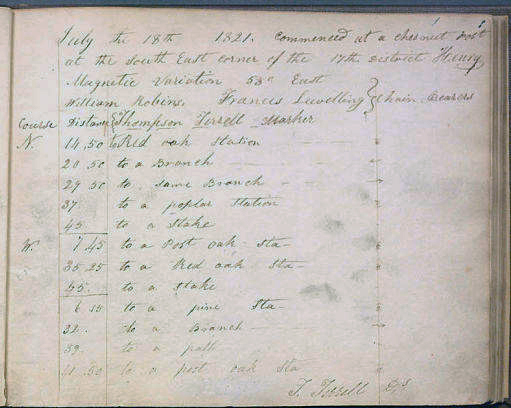 Figure 9. The first page of Terrell's field book. (Georgia Archives) |
John Thompson Terrell (1798-1864) was hired to survey and plat the Seventeenth District of what was then Henry County, but is now part of Fulton County. He had two "chain bearers" carrying the 66-foot-long chain that was used for measurements. They were identified in Terrell's field notes as Benjamin Hyde, William McCurley, James Goodwin, and Micajah Goodwin, but it is not clear which, if any of them, might have worked the entire survey. [14]
On 18 July 1821, Terrell commenced his survey at a "chestnut post" at the district's southeast corner, which is near the present corner of Virginia Avenue and Rosedale Road in the city's Virginia-Highland neighborhood. Over the next two months, he and his helpers walked the district, which encompasses what is now the City of Atlanta north of a line along Eighth Street as well as all of Sandy Springs.
Little is known about Thompson, but whatever his biography, he was meticulous. The plats that he drew for each land lot in the district noted even the most minor streams and branches, with most of the larger waterways given names that continue to be used today, including Utoy, Proctor, Peachtree, and Clear Creeks. Most importantly, in platting the land lots, Thompson went to the trouble of delineating not only a few major trails but also dozens of secondary trails, or paths as they were also called. Some of these smaller, less traveled trails may have led to individual farms, but many of them were part of the interconnecting local routes of travel common in every community. That level of detail is not found in the surveys of any of the surrounding districts, including the Fourteenth District which encompasses most of the city south of Eighth Street, and such documentation for local networks of trails anywhere is unusual.
In and around what is now the north side of the City of Atlanta, routes of travel were always limited by the necessity of crossing Peachtree Creek, which runs east and west across the city about four miles north of downtown and is a substantial stream most of the year. The Peachtree Trail's crossing was at Standing Peachtree, just above the confluence of Peachtree and Nancy Creeks, where a log foot bridge over the creek was likely maintained from an early date. In addition the creek could be forded at two or three points around and just east of what is now Howell Mill Road as well as around the confluence of the creek's two branches between Piedmont Road and Lindbergh Drive. There may have been other fords that could be used in the summer and fall when the water level of the creek was low.
The focus of most of the trails documented in the Seventeenth District survey was Standing Peachtree, but trails also converge on the fords in Peachtree Creek and the Chattahoochee River. There are obvious gaps in the mapping, and some trail fragments might have led only to an isolated farmstead. However, most of the Creek people had withdrawn further down the Chattahoochee River valley after the debacle of their civil war in 1813. That may have left trails and paths badly overgrown, and some may have been overlooked.
![]()
Annotated Plat of Survey, Seventeenth District |
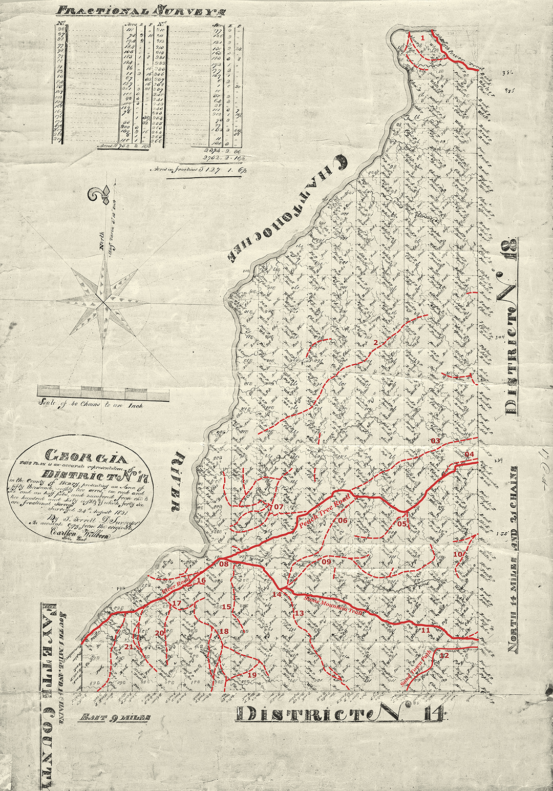
Figure 10. Annotated district plat of survey for the Seventeenth District of what was originally Henry, later DeKalb, and now Fulton County. The plat, which encompasses what is now the City of Atlanta north of Eighth Street as well as Sandy Springs, has been annotated to delineate the trails, paths, and roads depicted in the survey records from 1821. The solid red lines indicate the routes of Peachtree and River Roads and area trails that were delineated on the district plat. The lighter red, dashed lines are the trails or paths noted in the individual land-lot surveys. (Annotations by Tommy H Jones, 2014) |
The original surveys are in Records of the State Surveyor General, Record Group 003-03-024, District Surveys, 1821, Georgia Archives. The present study is the first effort at mapping all the trails delineated in the district's land-lot surveys.
1. At the northern end of the Seventeenth District, the trails led to fords in the Chattahoochee River. Terrell's plats delineate a short stretch of the Hightower Trail leading to Shallow Ford, three quarters of a mile downstream from the present Roswell Road bridge. The trails shown on the land-lot plats indicate a second ford a little over half a mile downstream from Shallow Ford, and a third a half mile or so below that. Shallow Ford was suitable for people and livestock but not for wagons, and during the historical period, wagons tended to use the lower fords. When a covered bridge was built just upstream from the present Roswell Road bridge around 1840, Shallow Ford was mostly abandoned, but at least one of the lower fords remained in active use. Roads to all three fords were recorded by Union cartographers in 1864, but the 1895 USGS map shows only the western-most ford. All of the fords were flooded after construction of Morgan Falls Dam in 1904.
2. Terrell recorded few trails in the remainder of what is now Sandy Springs north of I-285, perhaps because there simply were no trails in that area where the steep, hilly terrain offered fewer good river-crossings. One of the few trails delineated in that part of the district followed the high ground between Long Island and Nancy Creeks for nearly five miles from the district line to Land Lot 200, which is just east of what is now interchange of Mt. Paran Road and Interstate 75. It appears to have been part of the trail which left Peachtree Road west of Duluth generally on the course of Spalding Drive, Mount Vernon Road and Highway, Glenridge Drive west of Johnson Ferry Road, Roswell Road between Glenridge and Mt. Paran Roads, and the latter to its intersection with Randall Mill Road. Terrell did not show the continuation of the trail to the southwest from there, but the remainder of Mt. Paran Road and at least part of Ridgewood Road are likely to trace much of the rest of the trail’s route. Although this trail provided a way to Standing Peachtree, which was on the south side of Peachtree Creek, it probably developed as a way to the river ford, which was on the north side of the creek.
3. What may have been a significant shortcut to Standing Peachtree from the northeast diverged from Peachtree Road in a westerly direction a short distance north of today's Dresden Drive. No modern streets or roads in Brookhaven correspond to this trail, but Old Ivy Rd west of Ga. 400 and Habersham Road between Piedmont and W. Paces Ferry Roads closely follow its track. Where Habersham Road now takes a sharp turn to the south at Knollwood Drive, the trail apparently continued to the southwest and joined the original Peachtree Road, now W. Paces Ferry Road, more or less in front of the Governors Mansion.
4. Another trail segment appears to have left Peachtree Road a short distance east of the district line and traced a shallow arc a few hundred yards north of Peachtree Road, rejoining it just west of Lenox Square. The trail would have passed near the springhead of a small tributary to Nancy Creek, which may have been useful as a watering place. This segment may have been part of the original trail that was bypassed by the road builders in 1814.
5. Near the present intersection of Peachtree and Paces Ferry roads, two trails left the south side of Peachtree Road. The trail to the southeast most likely would have led to a ford in Peachtree Creek between Piedmont Road and Lindberg Drive; in the 1820s a wagon road from Decatur to Paces Ferry used the same ford. The trail to the southwest is generally the route of the modern Peachtree Road north of Andrews Drive, where the trail turned in a westerly direction, eventually connecting with trails leading to fords in Peachtree Creek near Howell Mill Road.
6. The trail delineated here led to a ford in Peachtree Creek just downstream from where Howell Mill Road crosses today. It generally followed Arden Road between W. Paces Ferry Road and Northside Drive, and then Castlewood Drive and Dover Road, and Howell Mill Road to the ford. Although not shown in the 1821 survey, Arden Road west of Northside Drive led to a second ford located about a quarter mile upstream from the Howell Mill ford. There was a third ford further upstream on the east side of the creek's horseshoe bend which seems to correspond with the "Rocky Ford" referenced in some early deeds. All three fords are documented in maps compiled by the US Army for its Civil War atlas.
7. Westminster School and I-75 now cover the site of an odd tangle of trails delineated on the annotated plat between Peachtree Road and the river. Using four different crossing points on Nancy Creek, these trails were connected to Peachtree Road as well as to the trail marked today by Mt. Paran Road, described above. While these trails might also have led to Standing Peachtree, which was mostly on the south side of Peachtree Creek, they probably developed as routes to the river ford, which was located north of the creek. Parts of several modern roadways generally follow the routes of the trails in this cluster, including much of Margaret Mitchell and Nancy Creek Drives, Ridgewood Road north of W. Wesley Road, Old Plantation Road, and W. Paces Ferry Road west of Nancy Creek.
8. Terrell delineated the intersection of the Peachtree and River roads and the Stone Mountain Trail on the district plat of survey but not on the plat for Land Lot 231. The earthen mound on which grew the legendary peach tree stood near the center of this land lot.
9. Peachtree Battle and Peachtree Hills Avenues are reminiscent of this trail's route connecting north-south roads at the fords near Howell Mill Road and those upstream near the forks of the creek. This trail utilized the third ford mentioned in #6 and at least part of it had been replaced by a road by the time Army engineers drew their maps in the 1860s. Three or four short spurs suggest that there are likely to have been connecting trails that were not recorded in 1821.
10. Shady Valley Drive, which was the continuation of Cheshire Bridge Road prior to construction of Atlanta's expressway system in the early 1950s, tracks a trail documented in the 1821 land-lot surveys.
11. Terrell mapped the trail between Stone Mountain and Standing Peachtree on the district plats and on the land-lot plats, and as noted above, much of its route can still be found in the routes of modern streets and roads.
12. Terrell's plat suggests that this trail leaft the Stone Mountain Trail somewhere east of the district line in Druid Hills, looped through Morningside and continued southwest across the southeast side of Piedmont Park to the district line, near near what is now the intersection of Eighth Street and Argonne Avenue. In surveying the Seventeenth District, Terrell thought this trail important enough to delineate on the district plat itself, where he labeled it "Sand Town Path." Although none of the surveyors of the surrounding land districts noted any part of the Sand Town Trail, Goff took Terrell's as the trail's main route. It seems improbable, however, that the main Sand Town Trail would not have kept to the high ground through Decatur and downtown Atlanta along which MARTA's East Line runs today, a route that would avoid all creek crossings and is also the most direct route to the site of Sand Town from what is now downtown Decatur. Most likely, Terrell recorded one of a braid of roads leading to Sand Town.
13. A portion of this trail became a major thoroughfare into Atlanta in the mid-nineteenth century. It would have intersected Trail #18 on the southwest side of the Georgia Tech campus a few hundred yards east of the present intersection of Howell Mill Road and Marietta Street. The northern part of the trail is marked today by DeFoors Ferry Road south of Collier Road and Howell Mill Road as it passes between the two city reservoirs.
14. The intersection of the trails from the Peachtree Creek fords with the Stone Mountain Trail was near the present intersection of DeFoors Ferry and Bohler roads; the former road traces the Stone Mountain Trail, while the latter road may have had its beginnings in a trail from the fords on Peachtree Creek near Howell Mill Road.
15. One of the trails converging on Standing Peachtree from the south ran across the top of a ridge in what is now the west side of Crest Lawn Cemetery, where there are excellent views to the northwest to the site of Standing Peachtree and the river.To the southeast, it must have converged on Trail 18, which tracked southeast from the River Road. Transformed into a wagon road in the 1820s, this was the main route to Marietta and northwest Georgia before construction of the railroads.
16. Leading southwest from Standing Peachtree was the River Road, which was most likely created at least in part out of an older Indian trail between Standing Peachtree and Sand Town. As noted above, Terrell's survey shows the original road following the northern part of today's Bolton Road and continuing south approximating the route of Parrott Avenue in Whittier Mill Village. By the time the River Road disappears from Terrell's district plat near the southwest corner of the Seventeenth District, it was running very close to the river. Cochran Road, which runs along the river in south Fulton County may trace an Indian trail that ran south from Sand Town. Evidence for a trail between those two segments and most of the site of Sand Town itself have been obliterated by development along Fulton Industrial Boulevard.
17. The modern intersection of Hollywood Road and Felker Ward Street mark this trail intersection. To the east, the Western & Atlantic Railroad obscures any connection with the trail that became part of Perry Boulevard.
18. The route of this trail might be traced in parts of Perry Boulevard and Marietta Street as far as Ashby Street, which is where Terrell's survey ended. From there it would have continued to the southeast through what is now downtown Atlanta.
19. Johnson Road NW approximates the route of this trail, which ran between the Perry Boulevard trail and the Hollywood Road trail.
20. The norhtern portion of Hollywood Road and part of Hightower Road evolved out of this trail
21. Construction of Interstate 285 and of the Atlanta Industrial Park disrupted historic patterns of travel, but the route of this trail is traced by Northwest Drive, which parallels a small tributary of Proctor Creek west of what is now Hightower Road.
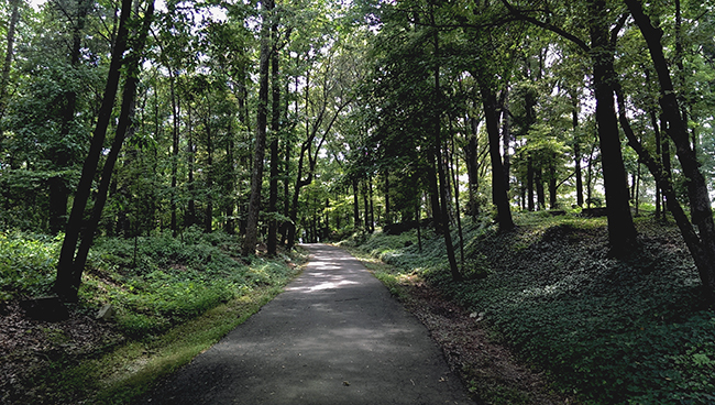
Figure 11. Old Marietta Road in Northwest Atlanta, mapped as a trail in the 1821 survey and developed as a wagon road after that, it is perhaps the best-preserved of the city's early roads that evolved out of ancient trails. (Photo by Tommy H Jones, 2014) |
![]()
Notes
1. Thomas Clark quoted in Robert Macfarlane, The Old Ways: A Journey on Foot (New York: Penguin Books, 2012), 13. Louis DeVorsey, "Indian Trails," New Georgia Encyclopedia, accessed 5 April 2014. On the ubiquity and character of early trails, see William Edward Meyer, "Indian Trails of the Southeast," Forty-second Annual Report of the Bureau of American Ethnology to the Secretary of the Smithsonian, 1924–1925 (Washington, D.C.: United States Government Printing Office, 1928), 739, 743.
2. John R. Swanton, "Preface" to William Moyer, "Indian Trails of the Southeast," 42nd Annual Report of Bureau of American Ethnology (1924–1925), 731.
3. John Goff, "The Hightower Trail," The Collections of the DeKalb Historical Society 1:2–4 (Decatur: Ga, 1951).
4. John Goff, "The Sandtown Trail,” The Atlanta Historical Bulletin 11, no. 4 (December 1966), argues that "Sand Town" originally referred to a large Creek town in Alabama. After 1814, some of its inhabitants moved east and settled the eponymous area near the prehistoric settlement of Buzzard's Roost in what is now south Fulton County. Also see Marion R. Hemperly, Historic Indian Trails of Georgia (Atlanta, GA: Garden Club of Georgia, 1989), 30–31. The present Sandtown Road in southwest Atlanta is likely not a relic of the trail from Rock Bridge but rather of a spur from Flat Shoals or other points to the southeast
5. The plat of survey for the Seventeenth District and the land lot surveys name the "Sand Town Path." State of Georgia, records of the State Surveyor General, Record Group 003-03-024, District Surveys, 1821, Georgia Archives.
6. John Goff, Placenames of Georgia (Athens: University of Georgia Press, 1974, paperback edition 2007), 171–2.
7. Collier quoted by Robert Adamson, "'The Oldest Inhabitant'—Came Here a Full Generation before Atlanta was Started—An Afternoon with the Pioneer at Home," Atlanta Constitution, 25 April 1897, microfilm at Atlanta-Fulton County Library.
8. The history of Standing Peachtree has long been an object of study for local historians. See Eugene M. Mitchell, 'The Story of 'The Standing Peachtree'," Atlanta Historical Bulletin 1, no. 2 (January 1928): 8-19; Wilbur G. Kurtz, "Standing Peachtree," Early Georgia 1, no. 2 (Fall 1950): 30–42; Franklin Garrett, Atlanta and Environs, Vol. 1 (Athens: University of Georgia Press, 1954, facsimile reprint 1969, 1982 printing), 8. Also N. Finegan and W. E. Merrill, Atlanta & vicinity: compiled from state map and information (Chattanooga, Tenn. : United States Army Corps of Topographical Engineers, 1864) notes a shoal in the river between the small island and the mouth of Peachtree Creek and that it was "fordable in summer."Mitchell notes the mound on the site of the waterworks pumping station on the south side of the creek. Franklin Garrett, Atlanta and Environs, Vol. 1 (University of Georgia Press, 1954, facsimile reprint 1969), 8, notes the presence of another mound on the west side of the river. A mound is thought to have been destroyed when Six Flags Over Georgia was built in the mid-1960s. Dylan Woodliff, "Revisiting Anneewakee Creek (9DO2)," Society for Georgia Archaeology, accessed 26 March 2015, discusses a recently destroyed mound on the west side of the river opposite today's Campbellton.
9. Quotation in Kurtz, "Standing Peachtree," 31.
10. Angela Pulley Hudson, Creek Paths and Federal Roads: Indians, Settlers, and Slaves and the Making of the American South (Chapel Hill, NC: University of North Carolina Press, 2010), 113.
11. James D'Angelo, Ph.D., R.P.A., "A New Take on an Old Story: Fort Daniel, Fort Peachtree, and the Road that Connected Them," Gwinnett Historical Society Heritage 43, No. 1 (Spring 2014), 6-8. D'Angelo has directed archaeological research on the site of Fort Daniel and has also done extensive archival research in state records to document the origins of the forts and the road between them. His conclusions challenge some of the traditional accounts of those early events. See "The Fort Daniel Foundation, Inc." accessed online at <http://www.thefortdanielfoundation .org/History.htm, 6 June 2014>. For the traditional story, see Franklin Garrett, Atlanta and Environs, Vol. 1, 13-16; and James C. Flanagan, History of Gwinnett County Georgia 1818–1943. Vol. 1. (Lawrenceville, GA: 1943, facsimile reprint by Alice Flanagan, 1995), 16–18.
12. Sarah Blackwell Gober Temple, The First Hundred Years: A Short History of Cobb County in Georgia. (Marietta, GA: Cobb Landmarks and Historical Society, 1997, reprint of 1935 edition), 18.
13. Charles J. Kappler, "Treaty with the Creek, 1805," Indian Affairs: Laws and Treaties, 85-86; Angela Pulley Hudson, Creek Paths and Federal Roads: Indians, Settlers, and Slaves and the Making of the American South (Chapel Hill: University of North Carolina Press, 2010), 113.
14. Record Group 003-03-024, Surveyor General -- Survey Records -- District Plats, and Record Group 003-03-025, Surveyor General -- Survey Records -- Field Notebooks are available online at Georgia Archives Virtual Vault.. Plats of individual land lots are on microfilm at Georgia Archives.
|
Sources of Information
Public Records
DeKalb County, Inferior Court, Minutes, 1823-1853. Microfilm, Georgia Archives.
DeKalb County, Superior Court, Record of Deeds and Mortgages, 1843-1853. Microfilm, Georgia Archives.
Fulton County, Superior Court, Record of Deeds and Mortgages, 1853-1890. Fulton County Courthouse and on microfilm, Georgia Archives.
State of Georgia, Records of the State's Surveyor General, Record Group 003-03-024, District Surveys, 1821, Georgia Archives.
Maps
Early, Eleazar. Map of the State of Georgia prepared from actual surveys & other documents." Savannah, Ga.: Eleazer Early; Philadelphia: John Melish and Samuel Harrison, 1818.
Samuel Breese and Sidney E. Morse, "Georgia," 1842, published by Harper and Brothers in 1845.
United States, Army of the Cumberland, Topographical Engineers Office. Atlanta : from Vincent's subdivision map, published by the City Council. Chattanooga TN: 1864.
___________, United States Geological Service (USGS), various maps, 1889-2014. \
___________, Department of War, Atlas to Accompany the Official Records of the Union and Confederate Armies, (Washington DC: 1895).
Vincent, Edward. Vincent's subdivision map of the city of Atlanta, Dekalb County, state of Georgia : showing all the lots, blocks, sections, &c., published in Savannah, GA., 1853. Library of Congress, Geography and Map Division.
Published Sources
D'Angelo, James J. "A New Take on an Old Story: Fort Daniel, Fort Peachtree, and the Road that Connected them. " The Heritage 42. no. 3. Gwinnett County Historical Society.
____ "The Original Peachtree Road and Why It Was Built." History. FortDanielFoundation.org. Web. 12 September 2017.
DeVorsey, Louis."Indian Trails." New Georgia Encyclopedia. Accessed on line at http://www.georgiaencyclopedia.org/articles/history-archaeology/indian-trails, 5 April 2014.
Doyle, Tony. "The Standing Peachtree," at http://bleufalcon.org/access/name.htm, accessed 19 November 2013.
Flanagan, James C. History of Gwinnett County Georgia 1818-1943 Vol. 1. Lawrenceville, GA: 1943, facsimile reprint by Alice Flanagan, 1995.
Garrett, Franklin. Atlanta and Environs, 2 Vols. (University of Georgia Press, 1954).
Goff, John H. Placenames of Georgia. Athens, GA: University of Georgia Press, 1975.
_________. "The Hightower Trail," The Collections of the DeKalb Historical Society 1. Decatur: Ga, 1951.
_________. "The Sandtown Trail," The Atlanta Historical Bulletin 11, no. 4 (December 1966).
Hemperly, Marion R. "Major Indian Trails in Georgia." Map, Georgia Department of Archives and History, 1979.
______________ Historic Indian Trails of Georgia. Atlanta, GA: Garden Club of Georgia, 1989.
Hudgins, Carl T. "DeKalb County Indian Trails," The Collections of the DeKalb Historical Society Vol. 1. Decatur, GA, 1951.
Hudson, Angela Pulley. Creek Paths and Federal Roads: Indians, Settlers, and Slaves and the Making of the American South. Chapel Hill, NC: University of North Carolina Press, 2010.
Kurtz, Wilbur G. "Standing Peachtree," Early Georgia 1, no. 5 (Fall 1950): 31-42.
Meyer, William Edward. "Indian Trails of the Southeast." Forty-second Annual Report of the Bureau of American Ethnology to the Secretary of the Smithsonian, 1924-1925, 727-854. Washington, D.C.: United States Government Printing Office, 1928.
Mitchell, Eugene M. "The Story of the Standing Peachtree," The Atlanta Historical Bulletin I no. 2 (January 1928): 8-19.
Price, Vivian. The History of DeKalb County, Georgia, 1822-1900. Fernandina Beach, FL: Wolfe Publishing Co., 1997.
|