 |
When the US War Department opened the “road to Standing Peach Tree” early in 1814, it was nothing but a rough wagon road hacked out of ancient Indian trails through the forest. Nearly forty miles long, the road followed the Eastern Continental Divide divide for part of that distance and avoided any stream crossings until reaching its destination on the Chattahoochee River at the mouth of Peachtree Creek. Created as a war road, it was part of Andrew Jackson’s relentless campaign to destroy the Creek Nation. In the 1820s, as the Creek were inevitably pushed aside, Peachtree Road became a major conduit for the mostly white settlers who poured in from northeast Georgia and the Carolinas. The road was so important that at its first session in May 1823, the county court “ordered that the road leading from the Standing Peach tree to Gwinnett County known by the hog mountain road, be a public road and that the same be put and kept in repair.” This is a guide to the progenitor of Atlanta’s Peachtrees.
In spite of enormous changes, much of the 38-mile route of the original Road to Standing Peach Tree can still be driven today, although not without dead ends and detours. Road names are confusing, with long stretches of Old Peachtree Road in Gwinnett County not part of the original war road at all. Segments of the 1814 road are now known not only as Peachtree Road, but also as Old Peachtree Road, S. Old Peachtree Road, S. Peachtree Street, N. Peachtree Street, and New Peachtree Road. Peachtree Street and Road between Buckhead and Downtown Atlanta were not part of the original road, but a mile and a half of the old war road between Norcross and Doraville is known simply as Peachtree Street. Other sections of the Road to Standing Peach Tree are ghosted today in Gwinnett County in parts of the Braselton Highway (SR 124), most of Rock Spring Road, Railroad Street, and May Road; in DeKalb County, by parts of Caldwell and Apple Valley Roads; and in the City of Atlanta, by the eastern end of W. Paces Ferry as well as all of Moores Mill Road.
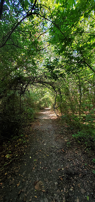
There are faint echoes of the rural landscape through which the road passes in Gwinnett County, but most of that landscape was subsumed by suburban Atlanta in the last quarter of the twentieth century. The exception is one remarkably untouched section of the nineteenth-century wagon road that remains just southwest of Duluth. Paved once, poorly, it is the best-preserved section of the original road. From Duluth through Norcross and Brookhaven and into Atlanta, the route of the old wagon road passes through an increasingly urbanized landscape, culminating in the glitz of Buckhead and the mansions of W. Paces Ferry Road, after which Bolton and the site of Standing Peachtree are a bit of a let down.
Hog Mountain to SR 317
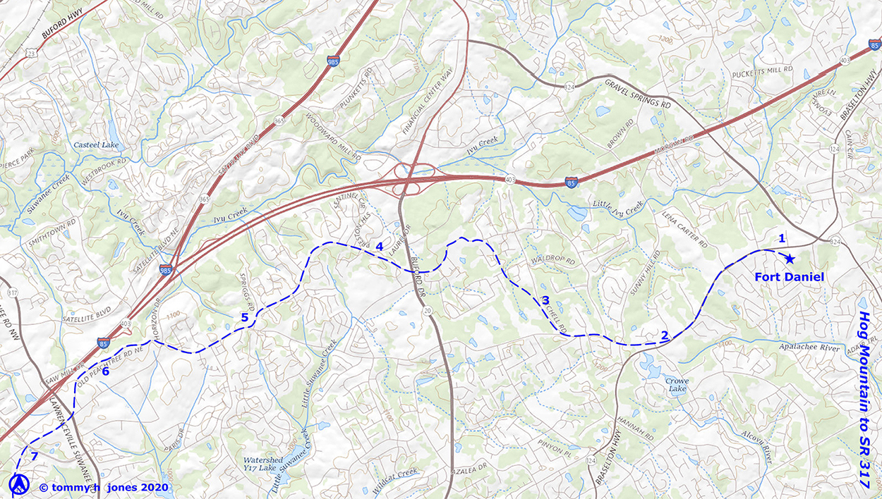 |
1. Hog Mountain is first noted on Early’s map of Georgia published in 1818, the year Gwinnett County itself was created by the state legislature. The origins of the name are obscure, but some say it arose from being a place to herd hogs before driving them to market in eastern Georgia. It is not really a mountain at all, but rather a broad plateau on the Eastern Continental Divide, separating the watersheds draining to the Atlantic Ocean and those to the Gulf of Mexico. The log fort that the War Department rebuilt in 1813 was on the highest point in the area, just over 1200′ above sea level. Today it can be noted as just a slight rise on the south side of today’s State Road (SR) 124, a few hundred yards west of Gravel Springs Road and about a mile and a half northeast of today’s Old Peachtree Road. The site has been leased by the county for the Fort Daniel Historic and Archaeological Research Park, and a Georgia historical marker memorializes the location.
2. Trending to the west-southwest from the fort, the route of the 1814 road generally followed the route of what is now SR 124, or Braselton Highway, for a mile and a half to a stop light where it turns to the west-northwest to follow Old Peachtree Road. Note that Old Peachtree Road south of SR 124 was not part of the 1814 war road. The original awkward intersection between these roads was altered in the early 2000s.
3. Less than a mile west of Highway 124, at Mitchell Road, the 1814 road turned north-northwest as it skirted the headwaters of the Alcovy and Yellow Rivers on the south and the waters of Ivy Creek on the north. Mitchell Road is an echo of the 1814 road, but the original route may have intersected Rock Springs Road a few hundred yards west of the present intersection of those roads.
4. West of Mitchell Road, Rock Springs Road generally tracks the route of the 1814 road around the headwaters of Little Suwanee Creek. There would be no stream crossings for the entire length of the original road, but by the end of the nineteenth century, that creek had been bridged to allow the present, more direct alignment of Old Peachtree Road west of Mitchell Road to take shape. The old sanctuary of the Rock Springs Methodist Church dates to 1882 and is one of only a handful of nineteenth century buildings that survive along the entire length of the old war road. The congregation dates to 1866 and has built a new building across the road, leaving the historic building abandoned and badly deteriorated.
5. The intersection of the western end of Rock Springs Road and Old Peachtree Road originally formed a broad Y, which was reconstructed to the present T intersection after 1993. Although the Hopewell Christian Church (organized 1866) building itself dates to the last quarter of the twentieth century, it seems to be oriented to the old intersection.
6. The 1820 plat shows three short, sharp turns as this section of the road passed back and forth across the line between two land lots. The platted turns are much more pronounced than the slight undulations in the route of the modern road and may have been drawn simply to note that the road crossed and re-crossed the land-lot line. As Old Peachtree Road intersects Horizon Drive, the general westward trend of the 1814 road turned to the southwest, following the Divide. The historic Y intersection of Old Peachtree Road with the western end of Horizon Drive was altered to a conventional T intersection after 1993.
SR 317 to Duluth
 |
7. West of SR 317, about a thousand feet of Old Peachtree Road was mostly abandoned after 1993 when McGuinness Ferry Road was extended to the state road and Old Peachtree Road was turned to meet the new Northbrook Parkway.
8. Continuing to the southwest, Old Peachtree Road turns westward as it crosses I-85 before turning northwest and then southwest again as it skirts the headwaters of Singleton and Daniel Creeks on its route to Duluth.
9. Evan Howell (1782–1868) established a ferry on the Chattahoochee River in 1833 with a road connecting it to Peachtree Road. After the railroad was constructed in 1869–70, the place was known as Howell’s Crossing until it was incorporated as Duluth in 1871. Here Old Peachtree Road and the continental divide run within a mile and a half of the Chattahoochee River.
10. In downtown Duluth, Buford Highway and the railroad obscure the precise location of the 1814 alignment, but it appears to have approximated the present route of Buford Highway south of the railroad between Old Peachtree Road and Railroad Street, where the 1814 road turned west in a trajectory to cross the railroad and what is now SR 120, which was the old road to Howell’s Ferry. The railroad was built very near to if not directly across the intersection of those roads. Main Street between SR 120 and S. Peachtree Street forms a shallow arc that probably had its genesis in the route of the 1814 war road.
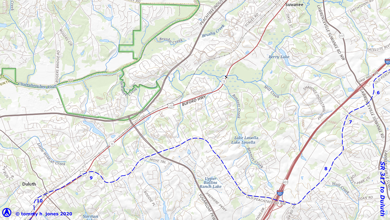
Duluth to Norcross
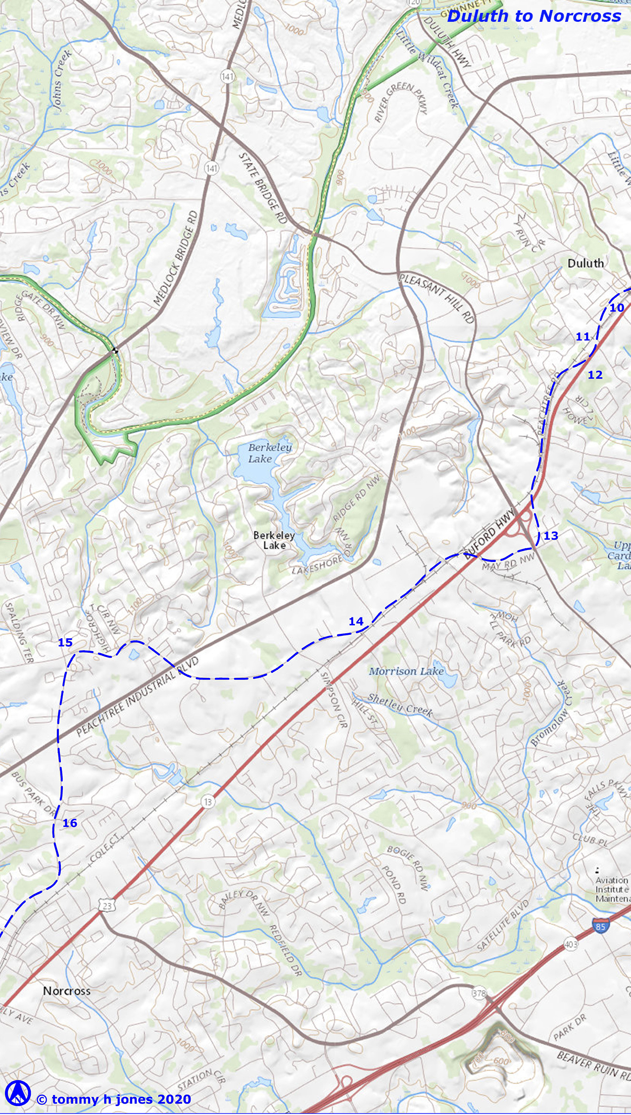 |
11. South from downtown Duluth, the route of the 1814 road is marked by S. Peachtree Street, which ran from Main Street to Buford Highway until part of it was abandoned when the route of Main Street was altered in recent years.
12. The original route is obscured for a short distance by Buford Highway to Peachtree Road (aka Old Atlanta Road), which closely parallels the east side of the railroad before re-entering the highway just before Pleasant Hill Road. Railroad construction no doubt affected the road, but since the road must have remained in use, the route was probably not altered except the few places where the railroad engineers thought a slightly different route was better. Closed to traffic for decades, most of it remains walkable and is the best-preserved portion of the old wagon road.
13. The route of the 1814 road more or less coincides with that of Buford Highway for a mile and a half before turning in a more southerly direction and making an arc that was partially destroyed by construction of the interchange between Pleasant Hill Road and Buford Highway in the early 200s.
14. East of Pleasant Hill Road, a half mile of the 1814 Road has been obscured by the railroad and Industrial Park Drive but is picked up by S. Old Peachtree Road about a mile southwest of Pleasant Hill Road.
15. S. Old Peachtree Road is part of the route of the 1814 road as it looped around the headwaters of Bromolow Creek. Its intersection with Spalding Drive, which continues to the west, echoes the track of an ancient trail that was an alternate route to Shallow Ford and to Standing Peachtree, marked today in part by Spalding Drive and Mt. Vernon Highway. A small farming community, Pinkneyville, developed around the intersection before the Civil War, but it disappeared with the rise of Norcross, two miles to the south in the 1870s.
16. From Spalding Drive, the 1814 road turned south, along with the divide, its route coinciding with Medlock Bridge Road until that road forks and turns east while N. Peachtree Street continues south into Norcross.
Norcross to Doraville
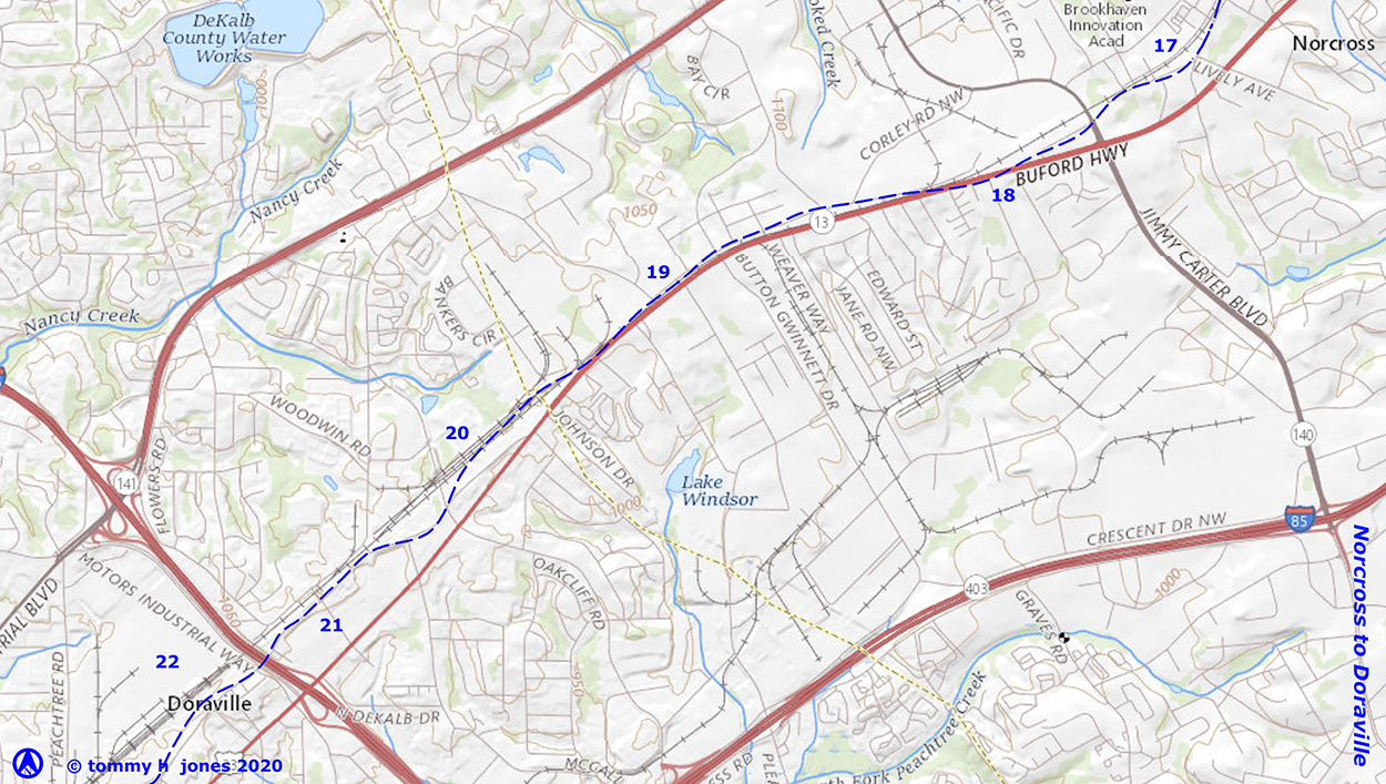 |
17. Norcross had its origins in 1869 when John J. Thrasher (1818–1899) bought 250 acres along Peachtree Road in western Gwinnett County. Thrasher’s settlement there was incorporated as Norcross in 1870, the year before the Air Line Railroad was completed through Gwinnett County. It was the second incorporated town in the county. The 1820 district plat of survey suggests that the 1814 road corresponded to the route of N. Peachtree Street until it crossed to the south side of the railroad to pick up S. Peachtree Street.
18. S. Peachtree Street dead ends at Buford Highway near Old Rockbridge Road, but historically the street continued to the west, crossing to the north side of the railroad, where the 1814 road generally followed the route of Old Peachtree Road along the north side of the railroad.
19. Nearly a mile of the old war road south of Amwiler Road is obscured by Buford Highway, but it can be picked up again in New Peachtree Road just inside the DeKalb County line. When the Creek ceded the land that became Gwinnett County in 1818, this boundary was described as following “the path leading from the high shoals of the Appalachie to the shallow ford on the Chatahochie,” which was the renowned Hightower Trail.
20. While much of the route of the 1814 war road can still be driven in Gwinnett County, significant parts in DeKalb County have been obscured, mostly by construction of the Airline Railroad after the Civil War and, to a lesser extent, of Buford Highway and I-285 in the second and third quarters, respectively, of the twentieth century.
21. The route of the 1814 road coincides with what is now New Peachtree Road as it runs along the southeast side of the railroad corridor between Buford Highway, a mile and a quarter north of I-285, and Shallowford Road, nearly three quarters of a mile south of the interstate. The name belies the fact that New Peachtree Road north of Shallowford Road more or less follows the route of the old 1814 road as it was platted in 1821. The road name arose in the 1890s when a new road was built to the southwest from Shallowford Road that eliminated the two grade crossings as the old road looped to the west through downtown Chamblee. Today New Peachtree Road extends for over four miles along the southeast side of the railroad corridor.
22. Incorporated in 1871, Doraville and its whistle stop on the railroad served the surrounding agricultural community until after World War II, when a new General Motors assembly plant and Atlanta’s explosive suburban growth transformed the town and the surrounding countryside.
Doraville to Brookhaven
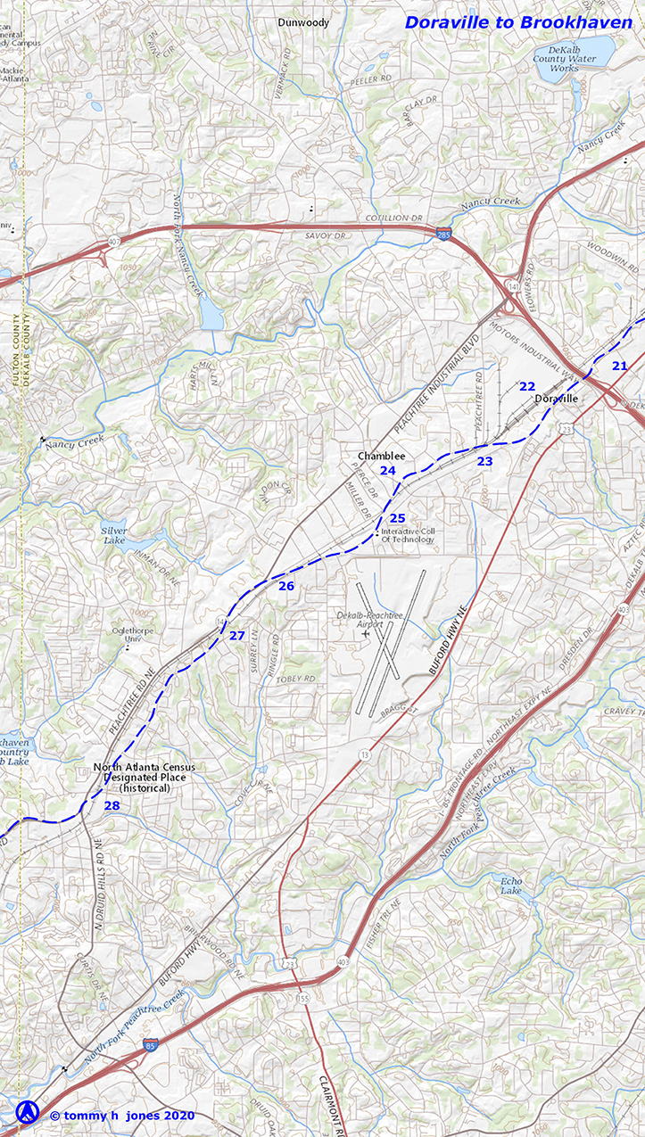 |
23. Just west of Shallowford Road, the railroad crossed the 1814 road at an oblique angle. There was a grade crossing at one time, and a short section of the old road branching off New Peachtree Road as S. Peachtree Road today is a reminder of that crossing, as is Peachtree Road’s sharp turn to the north where the crossing was eliminated.
24. The town of Chamblee was incorporated in 1907, but its downtown had already begun to evolve along the course of the 1814 road on the northwest side of the railroad. Running for less than a mile, the lazy meander of Peachtree Road through downtown Chamblee is a reminder of the road’s origins.
25. A quarter mile southwest of Chamblee-Tucker Road, the route of the old Peachtree Road is again interrupted by the railroad corridor but can be picked up on the southeast side of the railroad in that of New Peachtree Road. About a half mile before the route of the old road is again interrupted by the railroad and crosses to the northwest side of the tracks.
26. Just northeast of the present intersection of Peachtree and Ashford-Dunwoody Roads, the route of the 1814 road is interrupted by the railroad, but it continues on the southeast side of the tracks, echoed in the present alignment of parts of Caldwell Road. How long a grade crossing remained at this location is uncertain.
27. The route of the 1814 road was overwritten by the railroad and forced relocation of the road, probably just a few hundred yards, which then became New Peachtree Road. Confusingly, the route of the road today approximates some portions of the route of the 1814 road.
28. A few hundred yards southwest of Chamblee-Dunwoody Road, the route of the 1814 road is cut by the railroad but can be picked up on the southeast side of the tracks in the route of New Peachtree Road as it runs southwest of Clairmont Road. Parts of Caldwell and Apple Valley Roads are also an echo of the 1814 road, before it turned southwest and crossed the railroad corridor just north of Dresden Drive.
Brookhaven to Buckhead
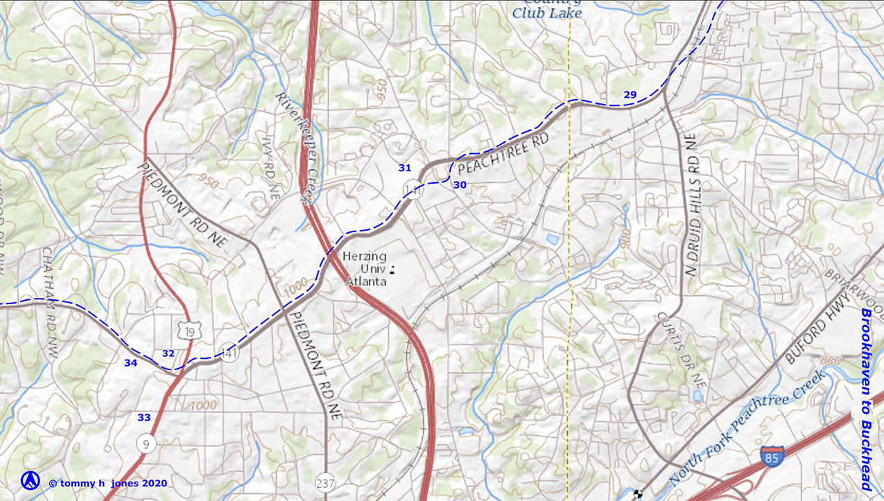 |
29. Between N. Druid Hills and Roswell Roads, the route of the modern road coincides more or less with the modern road. The road has been widened to as many as eight lanes of traffic around Lenox Square, but has maintained the historic route while obscuring its precise location.
30. At Roxboro Road, the present Peachtree Road deviates from the route of the 1814 road as it was delineated on the district plat. There the 1814 road is shown looping a few hundred yards to the south and back to the west to rejoin the route of the present road more or less encompassing the triangle of land on the south side of the road between Roxboro and Wieuca Roads.
31. The 1821 land-lot plats delineate a trail that bypassed the zig-zag route of the 1814 road. Paralleling the modern road a few hundred feet to the north, it was the predecessor of the sweeping curve in Peachtree Road as it crosses Wieuca Road, although as late as 1895 the USGS continued to map a zig-zagging route for Peachtree Road at this location.
32. The 1821 land-lot plats show Peachtree Road running to the southwest through Land Lot 61 before shifting to the northwest in Land Lot 99. In 1838, Henry Irby bought Land Lot 99 and established his residence and a tavern just northwest of the intersection of Peachtree and W. Paces Ferry Roads. For reference the intersection of N. Fulton Drive and Pharr Road mark the southeast corner of Land Lot 99 and the southwest corner of Land Lot 61 while the western lot line bisects the grounds of the Atlanta History Center. This would be the historic heart of Buckhead.
33. What is now Peachtree Road south from Paces Ferry Road to Andrews Drive was delineated as a trail in 1821, but it led to fords in Peachtree Creek near Howell Mill Road. Only in the 1840s with the rise of Atlanta and construction of Colliers Bridge did the modern route of Peachtree Road south of Andrews Drive reach its present configuration.
34. At the modern intersection of Peachtree, Paces Ferry, and Roswell Roads, the 1814 road looped in a more westerly direction, its route generally coinciding with W. Paces Ferry Road east of Moores Mill Road. Hardy Pace established his ferry at Vinings in the early 1830s, and a county road from Decatur to the ferry was opened around the same time. That road intersected Peachtree Road near Irby’s Buckhead Tavern. Only a small part of the route of the E. Paces Ferry that existed in the nineteenth century can be identified today beyond those blocks between Peachtree and Piedmont Roads.
Buckhead to Bolton
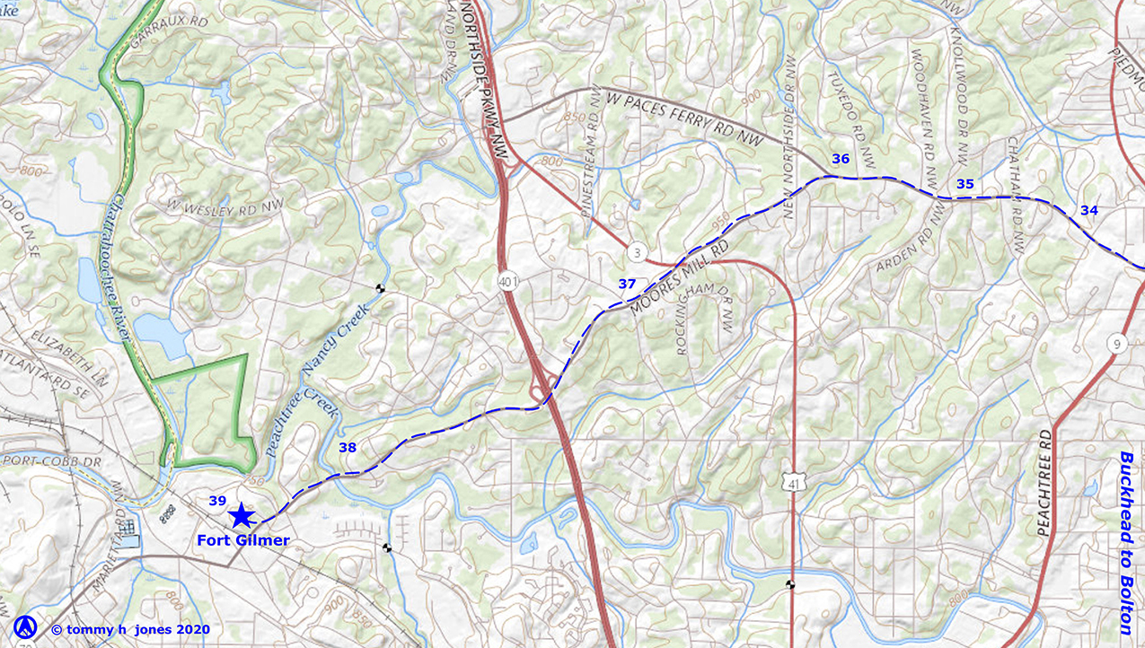 |
35. About a mile west of the site of the Buckhead tavern, Habersham Road north of W. Paces Ferry Road and Arden Road to the south originally formed a single trail and later road. It also included Old Ivy Road between SR 400 and Roswell Road as well as unidentifiable sections to the east of there connecting with Peachtree Road in Brookhaven. Habersham Road south of W. Paces Ferry Road may have been created out of old settlement roads but is basically a product of early twentieth-century real-estate development that transformed farms into suburban estates.
36. A half mile west of Habersham and Arden Roads, Moores Mill Road leads away to the southwest. Several of the 1821 plats note it as part of “Peach Tree Road” and it is referred to as being a part of “Old Peachtree Road” in Union Army orders during the Civil War.
37. The 1821 surveys record a trail leading west from Peachtree Road near its present intersection with Howell Mill Road. Part of the trail’s route is ghosted by Howell Mill Road itself to Margaret Mitchell Drive, and then parts of that drive south until the trail turned west to cross Nancy Creek and reach a ford in the Chattahoochee River just upstream from the mouth of Peachtree Creek.
38. In 1854, Thomas Moore (1828–1914) established a grist and saw mill on Peachtree Creek just off Old Peachtree Road. Located between Margaret Mitchell Drive, which was then a rural road, and the small branch that empties into Peachtree Creek in Land Lot 220, the mill gave its name to the road.
39. In a letter to Andrew Jackson in March 1814, James McC. Montgomery described the fort as being “on a commanding eminence below the mouth of a large creek . . . and right opposite a bend on the river from where the Gate of the Fort when built and view of the river can be had both up and down.” He also mentioned that they had built a bridge over Peachtree Creek “half a mile from the fort.” It seems most likely that the fort was on an unremarkable hill in the southeast quadrant of the land lot, just west of the intersection of Moores Mill and Ridgewood Roads. The hill rises twenty feet higher than the rise on the north side of the creek where some researchers have located the fort, and the Moores Mill Road bridge over Peachtree Creek is a half mile to the northeast. In addition, the 1821 plat of survey for the Seventeenth District clearly delineates the Road to Standing Peachtree crossing Peachtree Creek more or less where Moores Mill Road crosses today and intersecting the River Road and the Stone Mountain Trail three or four hundred yards west of the intersection of Moores Mill and Ridgewood Roads, which is assumed to have been at the heart of Standing Peachtree. The fort was most likely 500 or so feet west of that intersection.
Selected Sources
D’Angelo, James J. “The Original Peachtree Road and Why It Was Built.”
Gwinnett County Historical Society. DeKalb County Inferior Court Minutes, 1823–1853.
Doyle, Tony. Standing Peachtree Revisited. Atlanta, GA: Privately published, 2011.
Garrett, Franklin. Atlanta and Environs, 2 Vols. (University of Georgia Press, 1954).
Hudson, Angela Pulley. Creek Paths and Federal Roads: Indians, Settlers, and Slaves and the Making of the American South. Chapel Hill, NC: University of North Carolina Press, 2010.
State of Georgia, records of the state’s surveyor general, Record Group 003-03-024, 17th District Surveys, Georgia Archives.
United States, Army of the Cumberland, Topographical Engineers Office. Atlanta : from Vincent’s subdivision map, published by the City Council. Chattanooga TN: 1864. United States Geological Service (USGS), various maps, 1889–2019.
![]()