In vain the Creek Nation tried to define and protect its borders in the early nineteenth century, but regardless of any treaty guarantees, the invasion of their nation by a flood of white settlers continued. With little opposition from the State of Georgia, the newcomers flouted federal and tribal law by hunting, fishing, growing crops, and establishing large plantations inside the boundaries of the Creek Nation. Federal troops were sent to destroy farms, burn houses and remove the “intruders,” but as soon as the soldiers were gone, the squatters were back. Col. Hugh Montgomery, the federal government’s Indian agent, was “at a loss what to do” and bemoaned in a letter to the governor "the prevailing idea in Georgia (especially among the lower class) . . . [is] that they are the rightful owners of the soil, and that the Indians are mere tenants at will; and indeed, Sir, there is only one point on which all parties both high and low in Georgia agree, and that is, that they all want the Indian lands." [1]
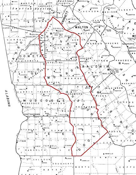
Figure 1.Detail from "State of Georgia Original and 1895 Counties and Land Lot Districts" with the 1821 Creek cession outlined in red. (Georgia Archives) |
In January 1821, the first Treaty of Indian Springs gained the State some 4.3 million acres of Creek territory, including the future site of Atlanta. Surveyed and platted into land districts and land lots in the summer and fall of 1821, the land was distributed by lottery by the end of the year. The influx of new settlers in 1822 precipitated creation of new counties, one of which was named DeKalb and included all of what are now central Fulton County and most of the City of Atlanta. The following year, the county seat, Decatur, was established along the ancient Sand Town-Stone Mountain Trail near its crossing with the trail from Indian Springs to Shallow Ford. By then there were already as many as 3,000 residents in the county.
In the spring of 1821, the State began surveying the Creek cession into land districts that were about nine miles square. These districts were further subdivided into square land lots of 202½ acres which were distributed in December 1821 in the State's fourth land lottery. For each district, the state contracted with a surveyor who was instructed
to take as accurately as possible the meanders of all water courses which shall form natural boundaries to any of the surveys; to note in field books to be kept by them respectively, the names of the corner and station trees which shall be marked and numbered under the direction of the surveyor general ; also all rivers, creeks, and other water courses which may be touched upon or crossed, in running any of the lines aforesaid; transcripts of which field books, after being compared with the originals by the surveyor general, and certified and signed on every page by the surveyor returning the same, shall be deposited in the surveyor general's office.[2]
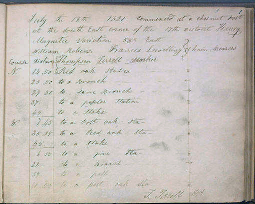
Figure 10. The first page of Terrell's field notebook. (Georgia Archives) |
John Thompson Terrell (1798-1864) was hired to survey and plat the Seventeenth District of what was then Henry County, but is now part of Fulton County. He had two "chain bearers" carrying the 66-foot-long chain that was used for measurements. They were identified in Terrell's field notes as Benjamin Hyde, William McCurley, James Goodwin, and Micajah Goodwin, but it is not clear which, if any of them, might have worked the entire survey. [3]
On 18 July 1821, Terrell commenced his survey at a "chestnut post" at the district's southeast corner, which is near the present corner of Virginia Avenue and Rosedale Road in the city's Virginia-Highland neighborhood. Over the next two months, he and his helpers walked the district, which encompasses what is now the City of Atlanta north of a line along Eighth Street as well as all of Sandy Springs.
Little is known about Thompson, but whatever his biography, he was meticulous. The plats that he drew for each land lot in the district noted even the most minor streams and branches, with most of the larger waterways given names that continue to be used today, including Utoy, Proctor, Peachtree, and Clear Creeks. Most importantly, in platting the land lots, Thompson went to the trouble of delineating not only a few major trails but also dozens of secondary trails, or paths as they were also called. Some of these smaller, less traveled trails may have led to individual farms, but many of them were part of the interconnecting local routes of travel common in every community. That level of detail is not found in the surveys of any of the surrounding districts, including the Fourteenth District which encompasses most of the city south of Eighth Street, and such documentation for local networks of trails anywhere is unusual.
In and around what is now the north side of the City of Atlanta, routes of travel were always limited by the necessity of crossing Peachtree Creek, which runs east and west across the city about four miles north of downtown and is a substantial stream most of the year. The Peachtree Trail's crossing was at Standing Peachtree, just above the confluence of Peachtree and Nancy Creeks, where a log foot bridge over the creek was likely maintained from an early date. In addition the creek could be forded at two or three points around and just east of what is now Howell Mill Road as well as around the confluence of the creek's two branches between Piedmont Road and Lindbergh Drive. There may have been other fords that could be used in the summer and fall when the water level of the creek was low.
The focus of most of the trails documented in the Seventeenth District survey was Standing Peachtree, but trails also converge on the fords in Peachtree Creek and the Chattahoochee River. There are obvious gaps in the mapping, and some trail fragments might have led only to an isolated farmstead. However, most of the Creek people had withdrawn further down the Chattahoochee River valley after the debacle of their civil war in 1813. That may have left trails and paths badly overgrown, and some may have been overlooked.
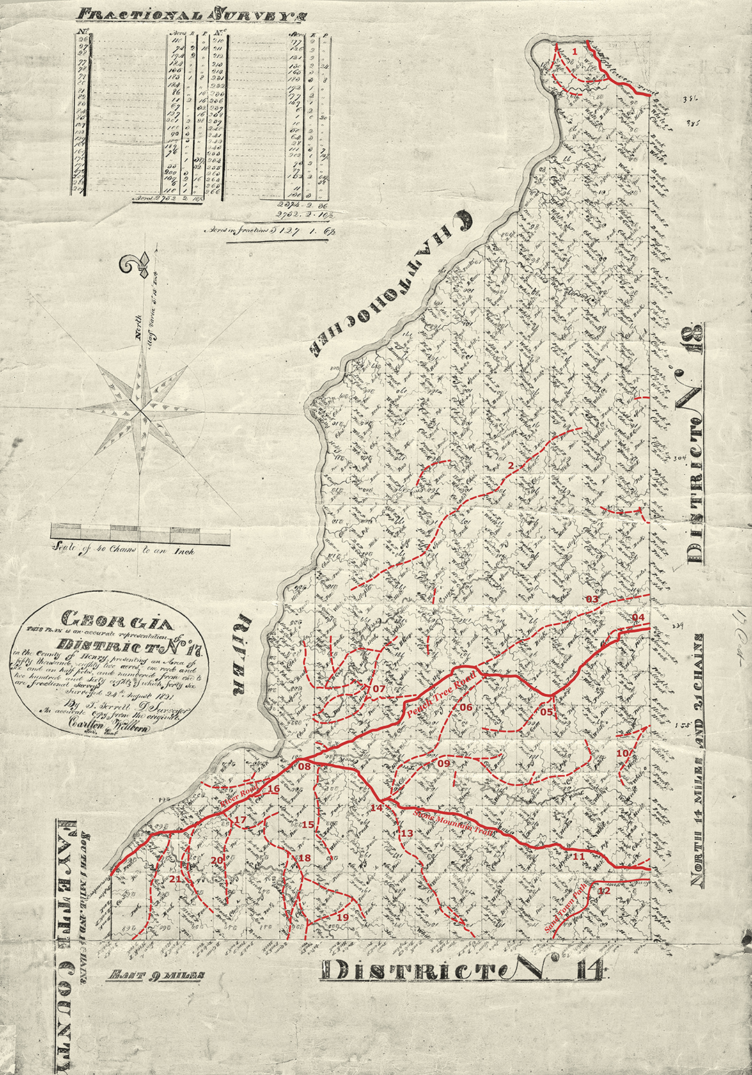
Figure 11. Annotated district plat of survey for the Seventeenth District of what was originally Henry, later DeKalb, and now Fulton County. The plat, which encompasses what is now the City of Atlanta north of Eighth Street as well as Sandy Springs, has been annotated to delineate the trails, paths, and roads depicted in the survey records from 1821. The solid red lines indicate the routes of Peachtree and River Roads and area trails that were delineated on the district plat. The lighter red, dashed lines are the trails or paths noted in the individual land-lot surveys. (Annotations by Tommy H Jones, 2014) |
|
Notes to Annotated District Plat of Survey
The original surveys are in Records of the State Surveyor General, Record Group 003-03-024, District Surveys, 1821, Georgia Archives. The present study is the first effort at mapping all the trails delineated in the land-lot surveys of the Seventeenth District.
1. At the northern end of the Seventeenth District, the trails led to fords in the Chattahoochee River. Terrell's plats delineate a short stretch of the Hightower Trail leading to Shallow Ford, three quarters of a mile downstream from the present Roswell Road bridge. The trails shown on the land-lot plats indicate a second ford a little over half a mile downstream from Shallow Ford, and a third a half mile or so below that. Shallow Ford was suitable for people and livestock but not for wagons, and during the historical period, wagons tended to use the lower fords. When a covered bridge was built just upstream from the present Roswell Road bridge around 1840, Shallow Ford was mostly abandoned, but at least one of the lower fords remained in active use. Roads to all three fords were recorded by Union cartographers in 1864, but the 1895 USGS map shows only the western-most ford. All of the fords were flooded after construction of Morgan Falls Dam in 1904.
2. Terrell recorded few trails in the remainder of what is now Sandy Springs north of I-285, perhaps because there simply were no trails in that area where the steep, hilly terrain offered fewer good river-crossings. One of the few trails delineated in that part of the district followed the high ground between Long Island and Nancy Creeks for nearly five miles from the district line to Land Lot 200, which is just east of what is now interchange of Mt. Paran Road and Interstate 75. It appears to have been part of the trail which left Peachtree Road west of Duluth generally on the course of Spalding Drive, Mount Vernon Road and Highway, Glenridge Drive west of Johnson Ferry Road, Roswell Road between Glenridge and Mt. Paran Roads, and the latter to its intersection with Randall Mill Road. Terrell did not show the continuation of the trail to the southwest from there, but the remainder of Mt. Paran Road and at least part of Ridgewood Road are likely to trace much of the rest of the trail’s route. Although this trail provided a way to Standing Peachtree, which was on the south side of Peachtree Creek, it probably developed as a way to the river ford, which was on the north side of the creek.
3. What may have been a significant shortcut to Standing Peachtree from the northeast diverged from Peachtree Road in a westerly direction a short distance north of today's Dresden Drive. No modern streets or roads in Brookhaven correspond to this trail, but Old Ivy Rd west of Ga. 400 and Habersham Road between Piedmont and W. Paces Ferry Roads closely follow its track. Where Habersham Road now takes a sharp turn to the south at Knollwood Drive, the trail apparently continued to the southwest and joined the original Peachtree Road, now W. Paces Ferry Road, more or less in front of the Governors Mansion.
4. Another trail segment appears to have left Peachtree Road a short distance east of the district line and traced a shallow arc a few hundred yards north of Peachtree Road, rejoining it just west of Lenox Square. The trail would have passed near the springhead of a small tributary to Nancy Creek, which may have been useful as a watering place. This segment may have been part of the original trail that was bypassed by the road builders in 1814.
5. Near the present intersection of Peachtree and Paces Ferry roads, two trails left the south side of Peachtree Road. The trail to the southeast most likely would have led to a ford in Peachtree Creek between Piedmont Road and Lindberg Drive; in the 1820s a wagon road from Decatur to Paces Ferry used the same ford. The trail to the southwest is generally the route of the modern Peachtree Road north of Andrews Drive, where the trail turned in a westerly direction, eventually connecting with trails leading to fords in Peachtree Creek near Howell Mill Road.
6. The trail delineated here led to a ford in Peachtree Creek just downstream from where Howell Mill Road crosses today. It generally followed Arden Road between W. Paces Ferry Road and Northside Drive, and then Castlewood Drive and Dover Road, and Howell Mill Road to the ford. Although not shown in the 1821 survey, Arden Road west of Northside Drive led to a second ford located about a quarter mile upstream from the Howell Mill ford. There was a third ford further upstream on the east side of the creek's horseshoe bend which seems to correspond with the "Rocky Ford" referenced in some early deeds. All three fords are documented in maps compiled by the US Army for its Civil War atlas.
7. Westminster School and I-75 now cover the site of an odd tangle of trails delineated on the annotated plat between Peachtree Road and the river. Using four different crossing points on Nancy Creek, these trails were connected to Peachtree Road as well as to the trail marked today by Mt. Paran Road, described above. While these trails might also have led to Standing Peachtree, which was mostly on the south side of Peachtree Creek, they probably developed as routes to the river ford, which was located north of the creek. Parts of several modern roadways generally follow the routes of the trails in this cluster, including much of Margaret Mitchell and Nancy Creek Drives, Ridgewood Road north of W. Wesley Road, Old Plantation Road, and W. Paces Ferry Road west of Nancy Creek.
8. Terrell delineated the intersection of the Peachtree and River roads and the Stone Mountain Trail on the district plat of survey but not on the plat for Land Lot 231. The earthen mound on which grew the legendary peach tree stood near the center of this land lot.
9. Peachtree Battle and Peachtree Hills Avenues are reminiscent of this trail's route connecting north-south roads at the fords near Howell Mill Road and those upstream near the forks of the creek. This trail utilized the third ford mentioned in #6 and at least part of it had been replaced by a road by the time Army engineers drew their maps in the 1860s. Three or four short spurs suggest that there are likely to have been connecting trails that were not recorded in 1821.
10. Shady Valley Drive, which was the continuation of Cheshire Bridge Road prior to construction of Atlanta's expressway system in the early 1950s, tracks a trail documented in the 1821 land-lot surveys.
11. Terrell mapped the trail between Stone Mountain and Standing Peachtree on the district plats and on the land-lot plats, and as noted above, much of its route can still be found in the routes of modern streets and roads.
12. Terrell's plat suggests that this trail leaft the Stone Mountain Trail somewhere east of the district line in Druid Hills, looped through Morningside and continued southwest across the southeast side of Piedmont Park to the district line, near near what is now the intersection of Eighth Street and Argonne Avenue. In surveying the Seventeenth District, Terrell thought this trail important enough to delineate on the district plat itself, where he labeled it "Sand Town Path." Although none of the surveyors of the surrounding land districts noted any part of the Sand Town Trail, Goff took Terrell's as the trail's main route. It seems improbable, however, that the main Sand Town Trail would not have kept to the high ground through Decatur and downtown Atlanta along which MARTA's East Line runs today, a route that would avoid all creek crossings and is also the most direct route to the site of Sand Town from what is now downtown Decatur. Most likely, Terrell recorded one of a braid of roads leading to Sand Town.
13. A portion of this trail became a major thoroughfare into Atlanta in the mid-nineteenth century. It would have intersected Trail #18 on the southwest side of the Georgia Tech campus a few hundred yards east of the present intersection of Howell Mill Road and Marietta Street. The northern part of the trail is marked today by DeFoors Ferry Road south of Collier Road and Howell Mill Road as it passes between the two city reservoirs.
14. The intersection of the trails from the Peachtree Creek fords with the Stone Mountain Trail was near the present intersection of DeFoors Ferry and Bohler roads; the former road traces the Stone Mountain Trail, while the latter road may have had its beginnings in a trail from the fords on Peachtree Creek near Howell Mill Road.
15. One of the trails converging on Standing Peachtree from the south ran across the top of a ridge in what is now the west side of Crest Lawn Cemetery, where there are excellent views to the northwest to the site of Standing Peachtree and the river.To the southeast, it must have converged on Trail 18, which tracked southeast from the River Road. Transformed into a wagon road in the 1820s, this was the main route to Marietta and northwest Georgia before construction of the railroads.
16. Leading southwest from Standing Peachtree was the River Road, which was most likely created at least in part out of an older Indian trail between Standing Peachtree and Sand Town. As noted above, Terrell's survey shows the original road following the northern part of today's Bolton Road and continuing south approximating the route of Parrott Avenue in Whittier Mill Village. By the time the River Road disappears from Terrell's district plat near the southwest corner of the Seventeenth District, it was running very close to the river. Cochran Road, which runs along the river in south Fulton County may trace an Indian trail that ran south from Sand Town. Evidence for a trail between those two segments and most of the site of Sand Town itself have been obliterated by development along Fulton Industrial Boulevard.
17. The modern intersection of Hollywood Road and Felker Ward Street mark this trail intersection. To the east, the Western & Atlantic Railroad obscures any connection with the trail that became part of Perry Boulevard.
18. The route of this trail might be traced in parts of Perry Boulevard and Marietta Street as far as Ashby Street, which is where Terrell's survey ended. From there it would have continued to the southeast through what is now downtown Atlanta.
19. Johnson Road NW approximates the route of this trail, which ran between the Perry Boulevard trail and the Hollywood Road trail.
20. The norhtern portion of Hollywood Road and part of Hightower Road evolved out of this trail
21. Construction of Interstate 285 and of the Atlanta Industrial Park disrupted historic patterns of travel, but the route of this trail is traced by Northwest Drive, which parallels a small tributary of Proctor Creek west of what is now Hightower Road.
|
![]()
Notes
1. Sarah Blackwell Gober Temple, The First Hundred Years: A Short History of Cobb County in Georgia. (Marietta, GA: Cobb Landmarks and Historical Society, 1997, reprint of 1935 edition), 18.
2. Charles J. Kappler, "Treaty with the Creek, 1805," Indian Affairs: Laws and Treaties, 85-86; Angela Pulley Hudson, Creek Paths and Federal Roads: Indians, Settlers, and Slaves and the Making of the American South (Chapel Hill: University of North Carolina Press, 2010), 113.
3. Record Group 003-03-024, Surveyor General -- Survey Records -- District Plats, and Record Group 003-03-025, Surveyor General -- Survey Records -- Field Notebooks are available online at Georgia Archives Virtual Vault.. Plats of individual land lots are on microfilm at Georgia Archives.
|
continue to |